
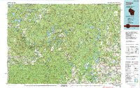
~ Wabeno WI topo map, 1:100000 scale, 30 X 60 Minute, Historical, 1990, updated 1991
Wabeno, Wisconsin, USGS topographic map dated 1990.
Includes geographic coordinates (latitude and longitude). This topographic map is suitable for hiking, camping, and exploring, or framing it as a wall map.
Printed on-demand using high resolution imagery, on heavy weight and acid free paper, or alternatively on a variety of synthetic materials.
Topos available on paper, Waterproof, Poly, or Tyvek. Usually shipping rolled, unless combined with other folded maps in one order.
- Product Number: USGS-8623427
- Free digital map download (high-resolution, GeoPDF): Wabeno, Wisconsin (file size: 31 MB)
- Map Size: please refer to the dimensions of the GeoPDF map above
- Weight (paper map): ca. 55 grams
- Map Type: POD USGS Topographic Map
- Map Series: HTMC
- Map Verison: Historical
- Cell ID: 68533
- Scan ID: 503689
- Imprint Year: 1991
- Woodland Tint: Yes
- Aerial Photo Year: 1988
- Edit Year: 1990
- Datum: NAD27
- Map Projection: Universal Transverse Mercator
- Map published by United States Geological Survey
- Map Language: English
- Scanner Resolution: 508 dpi
- Map Cell Name: Wabeno
- Grid size: 30 X 60 Minute
- Date on map: 1990
- Map Scale: 1:100000
- Geographical region: Wisconsin, United States
Neighboring Maps:
All neighboring USGS topo maps are available for sale online at a variety of scales.
Spatial coverage:
Topo map Wabeno, Wisconsin, covers the geographical area associated the following places:
- Klondike - Choate - Hollister - Mole Lake - Wabeno - Markton - Hickory Corners - Logan - Woodlawn - Athelstane - Pound - Crivitz - Lily - Pickerel - Perote (historical) - Oneva (historical) - Polar - Beaver - Freeman - Soperton - Langlade - Four Corners - Townsend - Carter - Coleman - Mountain - Padus - Lakewood - Minertown (historical) - Breed - White Lake - Frostville - Zoar - Bonita - Sherry Junction - Elton
- Map Area ID: AREA45.545-89-88
- Northwest corner Lat/Long code: USGSNW45.5-89
- Northeast corner Lat/Long code: USGSNE45.5-88
- Southwest corner Lat/Long code: USGSSW45-89
- Southeast corner Lat/Long code: USGSSE45-88
- Northern map edge Latitude: 45.5
- Southern map edge Latitude: 45
- Western map edge Longitude: -89
- Eastern map edge Longitude: -88


