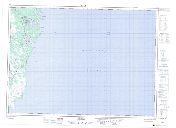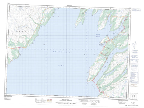
001K13 St Mary s Canada topo map, 1:50,000 scale
001K13 St Mary s NRCAN topographic map.
Includes UTM and GPS geographic coordinates (latitude and longitude). This 50k scale map is suitable for hiking, camping, and exploring, or you could frame it as a wall map.
Printed on-demand using high resolution, on heavy weight and acid free paper, or as an upgrade on a variety of synthetic materials.
Topos available on paper, Waterproof, Poly, or Tyvek. Usually shipping rolled, unless combined with other folded maps in one order.
- Product Number: NRCAN-001K13
- Parent Topo: TOPO-001K
- Map ID also known as: 001K13, 01K13, 1K13
- Unfolded Size: Approximately 26" high by 36" wide
- Weight (paper map): ca. 55 grams
- Map Type: POD NRCAN Topographic Map
- Map Scale: 1:50,000
- Geographical region: Newfoundland and Labrador, Canada
Neighboring Maps:
All neighboring Canadian topo maps are available for sale online at 1:50,000 scale.
Purchase the smaller scale map covering this area: Topo-001K
Spatial coverage:
Topo map sheet 001K13 St Mary s covers the following places:
- Beachy Cove - Bear Cove - Beckfords Cove - Big Sandy Cove - Black Cove - Branch Cove - Branch Gut - Caplin Cove - Cent Cove - Cow Cove - Deep Cove - Dicks Cove - Easter Cove - False Cape Cove - Fish Cove - Gaskiers Bay - Gaskiers Cove - Georges Cove - Grandfathers Cove - Grannys Gulch - Grassy Head Cove - Grates Cove - Green Gulch - Harrisons Cove - Holyrood Bay - Holyrood Bight - Island Cove - Jigging Cove - Judys Cove - Kerrys Ladder - Lance Cove - Langley Cove - Little Harbour - Little Sandy Cove - Long Cove - Lower Red Cove - Maggotty Cove - Mall Bay - Miners Cove - Mosquito Cove - Northeast Arm - Outside Bear Cove - Path End Bight - Red Cove - Red Cove - Seal Hole - Shoal Bay - Smokey Cove - St. Mary's Bay - St. Mary's Harbour - St. Shores Cove - Stakes Cove - The Cove - The Gut - Timber Cove - Upper Red Cove - Wester Cove - Whalers Cove - Wild Cove - Wild Cove - Barachois Beach - Bear Place - Gaskiers Shore - Graven Beach - Mall Bay Beach - Northeast Beach - Point La Haye Beach - Shoal Bay Beach - The Shore - Avalon Peninsula - Barachois Point - Barry Point - Beachy Point - Bear Cove Point - Beckford Head - Big Sandy Point - Birchy Head - Black Point - Branch Head - Cape English - Carols Point - Coalpit Point - Dallas Point - Deer Point - Delureys Point - Devils Chimney - Double Road Point - East Head - Eastern Head - False Cape - Fort Point - Frapeau Point - Georges Point - Gull Cove Point - Hares Cove Point - Haywards Point - Island Cove Point - Jacobs Head - Joe Rowes Point - John Finleys Point - La Haye Point - Lansecan Point - Little Harbour Point - Lizzy Point - Long Point - Long Point - Lower Barachois Point - Maggotty Point - Mosquito Point - Murphy Point - North Point - On the Ledge - Paddys Point - Peddles Point - Puncheon of Rum - Red Cove Point - Red Head - Red Point - Red Point - Rocky Point - Sandy Point - Shoal Bay Point - Small Point - South Point - Stakes Head - The Flat Place - Upper Barachois Point - Western Point - Wild Cove Point - Wild Head - Colinet Passage - Great Colinet Island - Barachois Ponds - Barrys Pond - Beach Pond - Beachy Cove Pond - Beaver Pond - Beaver Ponds - Big Hare Hill Pond - Big Pond - Black Duck Pond - Branch Pond - Cashmans Pond - Coote Pond - Cootes Pond - Coursey Pond - Cow Pond - Deer Pond - Eastern Pond - Grannys Pond - Gull Island Ponds - Gull Pond - Gull Pond - Gull Pond - Gull Ponds - Harbour Pond - Hare Hill Pond - Harrigans Pond - Hay Ponds - Hogans Pond - Holyrood Pond - Inside Driscoll Pond - Island Pond - Island Pond - Jigging Cove Pond - La Haye Pond - Little Pond - Long Pond - Long Pond - Maggotty Cove Pond - Mall Bay Pond - Match Block Ponds - Mosquito Pond - Mud Pond - Outside Driscoll Pond - Paddys Pond - Peddles Pond - Peddles Pond - Peters Pond - Point La Haye Pond - Red Cove Pond - Rocky Pond - Sandy Point Pond - Shoal Bay Pond - Simons Pond - Small Point Gully - Swimming Ponds - The Big Gully - The Big Gully - Three Duck Ponds - Three Necked Pond - Topsail Pond - Trout Ponds - Trouting Pond - Trouting Ponds - Wild Cove Pond - Wood Chisel Gullies - Wood Chisel Pond - Woody Hill Ponds - Woody Pond - Bear Path Hill - Big Head - Big Rocky Hill - Black Point Neck - Brimstone Head - Burnt Hill - Burnt Hills - Darling Head - Dry Ridge - Fox Nob - Hare Hill - Hare Hill - Hare Hill Longstone - Inside Hill - Joe Rowes Knob - Lansecan Hill - Little Harbour Hills - Little Rocky Hill - Long Hill - Maggotty Cove Hills - Man of Rocks - Middle Neck - Mount Pinsent - Naked Man - North Head - Peters Nap - Peters River Hill - Red Head Hills - Sandy Point Hill - Shoal Bay Hill - The Highlands - The Lookout - The Lookout - The Round Knob - The Scrape - Topsail - Topsail Hill - White Hills - Holyrood Pond Provincial Park - Point La Haye Provincial Park - Beachy Cove Brook - Beckfords River - Big Drop River - Big Mount Gully - Branch River - Bucket River - Bucket River - Burnt Hill River - Cootes Pond River - Deer Pond River - Drop River - Fox's River - Freshwater Brook - Gaskiers River - Grandfathers River - Grannys River - Gull Cove River - Gull Island Brook - Hunters Pool - John Englishs Gully - Long Stone Gully - Lookout Gully - Looneys River - Lower Barasway River - Mall Bay Brook - Middle Gut River - Mitchells Brook - North Bucket River - Old Sams River - Path End River - Peddles Gully - Peter's River - Quakers River - Red Cove Gully - Red Head River - Redmans River - Riverhead River - Ryans River - Sams Brook - Small Mount Gully - Vails Brook - Vail's Brook - Wood Chisel River - Easter Fork - Northwest Fork - Beckford Path - Crossing Place Road - Path End Road - Timber Cove Road - Bank Rock - Beckford Shoal - Coalpit Shoal - Daly Rock - Greet Rock - Hare's Ears - La Haye Shoal - Lansecan Rocks - Mussel Rock - Paddock Shoal - Red Cove Rock - Red Head Rock - The Bantam - The Lump - Branch - Gaskiers-Point La Haye - Riverhead - St. Mary's - St. Vincent's-St. Stephen's-Peter's River - Barachois - Beckfords - Cootes Pond - Gaskiers - Graven Bank - Gulch - Mall Bay - Middle Gut - Mosquito - Path End - Peter's River - Point La Haye - St. Stephens - St. Vincent's - The Flats - Englishs Gulch - Roches Gulch - Walshs Gully - Bakeapple Marsh - Blow Hole Marsh - Fox Burrow Marsh - Ganderose March - High Marsh - Mall Bay Barrens