
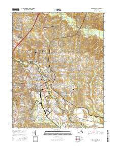
~ Fredericksburg VA topo map, 1:24000 scale, 7.5 X 7.5 Minute, 2016
Fredericksburg, Virginia, USGS topographic map dated 2016.
Includes geographic coordinates (latitude and longitude). This topographic map is suitable for hiking, camping, and exploring, or framing it as a wall map.
Printed on-demand using high resolution imagery, on heavy weight and acid free paper, or alternatively on a variety of synthetic materials.
Topos available on paper, Waterproof, Poly, or Tyvek. Usually shipping rolled, unless combined with other folded maps in one order.
- Product Number: USGS-8264420
- Free digital map download (high-resolution, GeoPDF): Fredericksburg, Virginia (file size: 27 MB)
- Map Size: please refer to the dimensions of the GeoPDF map above
- Weight (paper map): ca. 55 grams
- Map Type: POD USGS Topographic Map
- Map Series: US Topo
- Map Verison: Current
- Cell ID: 16313
- Datum: North American Datum of 1983
- Map Projection: Transverse Mercator
- Map Cell Name: Fredericksburg
- Grid size: 7.5 X 7.5 Minute
- Date on map: 2016
- Map Scale: 1:24000
- Geographical region: Virginia, United States
Neighboring Maps:
All neighboring USGS topo maps are available for sale online at a variety of scales.
Spatial coverage:
Topo map Fredericksburg, Virginia, covers the geographical area associated the following places:
- The Hills of Stafford - Lynwood - Braehead Woods - Chapel View - Ridge Pointe - McCarthys Corner - Confederate Ridge - Stones Corner - Joseph Sullivan Estates - Deacon Woods - Mayfield - Highland Homes - Grace Shelton Family Subdivision - Maryes Heights - Phillips - Sunnyside Division - Oakland and Fairview - Chatham Farms - Fitzhugh - Falmouth Village - North Potomac - Bellvue - Argyle Heights - River Heights - Hart Division of Little Falls - Jefferson Place - Hamlin Hills - Light Oak Glen - Artillery Ridge - Bourne - Northridge - Argyle Hills - Fourmile Fork - Woodland - Argyle Terrace - Cedar Bluff - White Oak - Butterfield - Falmouth - Blythedale - Ingleside - Cottage Green - Sullivan - Mount Ringold Farm - East Chatham Heights - Cranes Corner - Concord Heights - Briarwood Estates - E O Brooks Subdivision - Leeland Station - The Hills of Potomac Creek - Graninger - Kendallwood Estates - Charlestown Commons - Cannon Ridge - Wellford Sullivan Estate - Ferry Farm - Hickory Ridge - Wildcat Corner - Walter Roberson Estate - Huntington Hills - North Clearview Heights - Belmont - Misty Forest - Fairview and Oakland - Little Falls - Basil Gordon - Upper Redoubt Heights - North Ferry Farms - Bexley Manor - Heritage Commons - Chatham Heights - Holly Ridge - Chatham Village - Hazel Hill - Moreland - Bel Air - Blaisdell Subdivision - Debruyn - Falmouth Heights - High School Heights - Deacon Road Estates - Hoyt - Brookstone - Deer Forest - Cranewood - Potomac - Part Little Falls - Burnside - Leeland Creek Estates - Bel Plains Estates - Dahlgren Junction (historical) - Hillcrest Terrace - Fall Run Park - Victoria Woods - Greenstreet Mobile Home Park - Clarion Woods - Waltlou Mobile Home Park - O Bannon Land - Kendallwood East
- Map Area ID: AREA38.37538.25-77.5-77.375
- Northwest corner Lat/Long code: USGSNW38.375-77.5
- Northeast corner Lat/Long code: USGSNE38.375-77.375
- Southwest corner Lat/Long code: USGSSW38.25-77.5
- Southeast corner Lat/Long code: USGSSE38.25-77.375
- Northern map edge Latitude: 38.375
- Southern map edge Latitude: 38.25
- Western map edge Longitude: -77.5
- Eastern map edge Longitude: -77.375


