
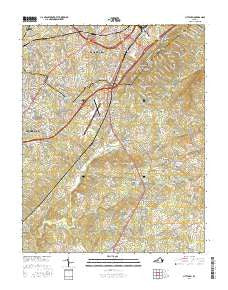
~ City Farm VA topo map, 1:24000 scale, 7.5 X 7.5 Minute, 2016
City Farm, Virginia, USGS topographic map dated 2016.
Includes geographic coordinates (latitude and longitude). This topographic map is suitable for hiking, camping, and exploring, or framing it as a wall map.
Printed on-demand using high resolution imagery, on heavy weight and acid free paper, or alternatively on a variety of synthetic materials.
Topos available on paper, Waterproof, Poly, or Tyvek. Usually shipping rolled, unless combined with other folded maps in one order.
- Product Number: USGS-8247808
- Free digital map download (high-resolution, GeoPDF): City Farm, Virginia (file size: 26 MB)
- Map Size: please refer to the dimensions of the GeoPDF map above
- Weight (paper map): ca. 55 grams
- Map Type: POD USGS Topographic Map
- Map Series: US Topo
- Map Verison: Current
- Cell ID: 8831
- Datum: North American Datum of 1983
- Map Projection: Transverse Mercator
- Map Cell Name: City Farm
- Grid size: 7.5 X 7.5 Minute
- Date on map: 2016
- Map Scale: 1:24000
- Geographical region: Virginia, United States
Neighboring Maps:
All neighboring USGS topo maps are available for sale online at a variety of scales.
Spatial coverage:
Topo map City Farm, Virginia, covers the geographical area associated the following places:
- Seminole Ridge - Brush Tavern - Sheffield - Forest Dale - Lawyers - Russellwood - Lanes Well Fork - College Park - Woodlawn - Belmont Acres - Vista Acres - Oak Grove - Beechwood Hills - Kenwood Hills - Green Meadows - Yellow Branch - Doral Acres - Windsor Hills - Vista Acres - Deer Creek - Sunny Banks - Happy Valley - Richland Hills - City Farm - Sherwood Forest - Heritage Hills - Brookville - Powhatan - Lo Roy Acres - Locust Gardens Mobile Home Park - Woodbine Acres - Whetstone Hills - Southland Acres - Tulip Tree Acres - Hillsman Corner
- Map Area ID: AREA37.37537.25-79.25-79.125
- Northwest corner Lat/Long code: USGSNW37.375-79.25
- Northeast corner Lat/Long code: USGSNE37.375-79.125
- Southwest corner Lat/Long code: USGSSW37.25-79.25
- Southeast corner Lat/Long code: USGSSE37.25-79.125
- Northern map edge Latitude: 37.375
- Southern map edge Latitude: 37.25
- Western map edge Longitude: -79.25
- Eastern map edge Longitude: -79.125


