
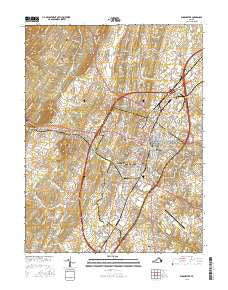
~ Winchester VA topo map, 1:24000 scale, 7.5 X 7.5 Minute, 2016
Winchester, Virginia, USGS topographic map dated 2016.
Includes geographic coordinates (latitude and longitude). This topographic map is suitable for hiking, camping, and exploring, or framing it as a wall map.
Printed on-demand using high resolution imagery, on heavy weight and acid free paper, or alternatively on a variety of synthetic materials.
Topos available on paper, Waterproof, Poly, or Tyvek. Usually shipping rolled, unless combined with other folded maps in one order.
- Product Number: USGS-8240809
- Free digital map download (high-resolution, GeoPDF): Winchester, Virginia (file size: 27 MB)
- Map Size: please refer to the dimensions of the GeoPDF map above
- Weight (paper map): ca. 55 grams
- Map Type: POD USGS Topographic Map
- Map Series: US Topo
- Map Verison: Current
- Cell ID: 49377
- Datum: North American Datum of 1983
- Map Projection: Transverse Mercator
- Map Cell Name: Winchester
- Grid size: 7.5 X 7.5 Minute
- Date on map: 2016
- Map Scale: 1:24000
- Geographical region: Virginia, United States
Neighboring Maps:
All neighboring USGS topo maps are available for sale online at a variety of scales.
Spatial coverage:
Topo map Winchester, Virginia, covers the geographical area associated the following places:
- Brookneil - Sherwood Forest - Senseny Heights - Country Club Estates - Southview - Day - Mar Village - Arcadia Mobile Home Park - Stonebrook Farms - Round Hill - Shenandoah Mobile Home Park - Winchester - Westwood - Ash Hollow Estates - Frederick Heights - Nain - Spring Valley - Bufflick Heights - Stonewall Orchard - Heritage Hills - Woodchuck Heights - Hill Crest - North Frederick Terrace - Fairway Estates - Opequon - Kernstown - Green Acres - College Park - Rolling Fields - Sunnyside - Valley Acres - Echo Village - Chambersville - Plainfield Heights - Wellington Acres - Albin - Miller Heights - Jackson Woods
- Map Area ID: AREA39.2539.125-78.25-78.125
- Northwest corner Lat/Long code: USGSNW39.25-78.25
- Northeast corner Lat/Long code: USGSNE39.25-78.125
- Southwest corner Lat/Long code: USGSSW39.125-78.25
- Southeast corner Lat/Long code: USGSSE39.125-78.125
- Northern map edge Latitude: 39.25
- Southern map edge Latitude: 39.125
- Western map edge Longitude: -78.25
- Eastern map edge Longitude: -78.125


