
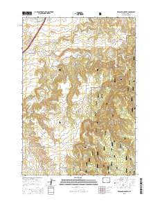
~ Red Canyon Creek WY topo map, 1:24000 scale, 7.5 X 7.5 Minute, 2015
Red Canyon Creek, Wyoming, USGS topographic map dated 2015.
Includes geographic coordinates (latitude and longitude). This topographic map is suitable for hiking, camping, and exploring, or framing it as a wall map.
Printed on-demand using high resolution imagery, on heavy weight and acid free paper, or alternatively on a variety of synthetic materials.
Topos available on paper, Waterproof, Poly, or Tyvek. Usually shipping rolled, unless combined with other folded maps in one order.
- Product Number: USGS-7862083
- Free digital map download (high-resolution, GeoPDF): Red Canyon Creek, Wyoming (file size: 24 MB)
- Map Size: please refer to the dimensions of the GeoPDF map above
- Weight (paper map): ca. 55 grams
- Map Type: POD USGS Topographic Map
- Map Series: US Topo
- Map Verison: Current
- Cell ID: 37305
- Datum: North American Datum of 1983
- Map Projection: Transverse Mercator
- Map Cell Name: Red Canyon Creek
- Grid size: 7.5 X 7.5 Minute
- Date on map: 2015
- Map Scale: 1:24000
- Geographical region: Wyoming, United States
Neighboring Maps:
All neighboring USGS topo maps are available for sale online at a variety of scales.
Spatial coverage:
Topo map Red Canyon Creek, Wyoming, covers the geographical area associated the following places:
- Poison Creek - Bush Ranch - Cold Springs Creek - Corral Creek - Rocky Ford Reservoir - Thompson Ranch - Green Mountain Draw - Koksh Ranch - Jones, Bury, and Murdock Property Number One Mine - Rocky Ford Dam - Cranberry Spring - Seely Ranch - Riflepit Divide - Spring Draw - Idol Gulch - Red Canyon Creek - Quail Spring - Jones Ranch - Buck Hollow - Rocky Ford Creek - Surprise Gulch - Deer Corral Spring - Miller Ranch - Hamilton Spring - Lincoln Ranch - Hegge Ranch - Thompson Gulch - Cranberry Springs Gulch - Knapp Spring - Bear Creek Mountains Mine - Black Haw Gulch - Surprise Gulch Spring - Grand Canyon - Williams Divide - Manhattan Gulch - Inum Group Mine
- Map Area ID: AREA44.544.375-104.25-104.125
- Northwest corner Lat/Long code: USGSNW44.5-104.25
- Northeast corner Lat/Long code: USGSNE44.5-104.125
- Southwest corner Lat/Long code: USGSSW44.375-104.25
- Southeast corner Lat/Long code: USGSSE44.375-104.125
- Northern map edge Latitude: 44.5
- Southern map edge Latitude: 44.375
- Western map edge Longitude: -104.25
- Eastern map edge Longitude: -104.125


