
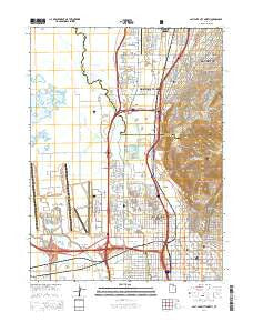
~ Salt Lake City North UT topo map, 1:24000 scale, 7.5 X 7.5 Minute, Current, 2014
Salt Lake City North, Utah, USGS topographic map dated 2014.
Includes geographic coordinates (latitude and longitude). This topographic map is suitable for hiking, camping, and exploring, or framing it as a wall map.
Printed on-demand using high resolution imagery, on heavy weight and acid free paper, or alternatively on a variety of synthetic materials.
Topos available on paper, Waterproof, Poly, or Tyvek. Usually shipping rolled, unless combined with other folded maps in one order.
- Product Number: USGS-7789024
- Free digital map download (high-resolution, GeoPDF): Salt Lake City North, Utah (file size: 32 MB)
- Map Size: please refer to the dimensions of the GeoPDF map above
- Weight (paper map): ca. 55 grams
- Map Type: POD USGS Topographic Map
- Map Series: US Topo
- Map Verison: Current
- Cell ID: 71500
- Datum: North American Datum of 1983
- Map Projection: Transverse Mercator
- Map Cell Name: Salt Lake City North
- Grid size: 7.5 X 7.5 Minute
- Date on map: 2014
- Map Scale: 1:24000
- Geographical region: Utah, United States
Neighboring Maps:
All neighboring USGS topo maps are available for sale online at a variety of scales.
Spatial coverage:
Topo map Salt Lake City North, Utah, covers the geographical area associated the following places:
- Western - Marsden - Kinneys Copper Plant - Sunshine - Poplar Grove Addition - Miles and Hamiltons Addition - North Crest Park Condominium - Mountains Meadows - Taylors - Lynch and Glassmans - Featherstone - Catherine Circle - American Plaza Condominium - Earl D Grays - Williamsburgh - Cone and Roberts Addition - Alda Verda - Lake View - Highlands - Wright Efficiency Park - Park Rose - Wilkes - Rock Springs - Jordan Addition - Jenkins Orchard - Briarwood Acres - Woods Cross - Menlove Estates - Byers and Tolles Addition - Mandolin Condominium - Pedersen - Burlington Addition West - South Church Heights - North Point Cove - Sundown - North Temple Street - Hillside Oaks - Kelsey and Gillespie - Hanson - Martins - Nelhoca Place - Valerie - Normandy Park - Bullock - Fritsch and Zulchs Addition - Valley Side Circle - Mar Vista - Zion Summit Condominium - City View Addition - Summer Garden Townhouse Condominium - Walkers - Kinney and Gourlays Improved City Plat - Avondale - Thompsons - Geurts - West Salt Lake - Church Heights - Val Vista - Rustic Acres - Chalet - Great Westside - Brown - Gold Mine Acres Condominium - Berkshire West - The Terraces of Rose Park Condominium - Linda Loma Acres - Bridlewood - Wall Street Condominium - South Valley View - Canyon Road Towers Condominium - Airport East Business Park - Meadowmont - Skyline Park - Newport Heights Condominium - Blaine - Celesta Vu Condominium - Jackson Condominium - The Villa Granade Condominium - Langton Park - Hunters - Snow - Summer Oak - Riverside - Robinvale Estates - Whalons Addition - Hillside Gardens - Colorado - Bunnells - Lakeview Estates - Vineyard Condominium - Orchard Corners Condominium - Star Heights - North Salt Lake - Le Mar Addition - North Canyon Heights - Panorama Apartments Condominium - Whitehead - Terrace Falls Condominium - Sconberg - Capitol Heights Condominium
- Map Area ID: AREA40.87540.75-112-111.875
- Northwest corner Lat/Long code: USGSNW40.875-112
- Northeast corner Lat/Long code: USGSNE40.875-111.875
- Southwest corner Lat/Long code: USGSSW40.75-112
- Southeast corner Lat/Long code: USGSSE40.75-111.875
- Northern map edge Latitude: 40.875
- Southern map edge Latitude: 40.75
- Western map edge Longitude: -112
- Eastern map edge Longitude: -111.875


