
~ Pole Mountain UT topo map, 1:24000 scale, 7.5 X 7.5 Minute, Current, 2014
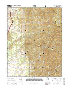
Pole Mountain, Utah, USGS topographic map dated 2014.
Includes geographic coordinates (latitude and longitude). This topographic map is suitable for hiking, camping, and exploring, or framing it as a wall map.
Printed on-demand using high resolution imagery, on heavy weight and acid free paper, or alternatively on a variety of synthetic materials.
Topos available on paper, Waterproof, Poly, or Tyvek. Usually shipping rolled, unless combined with other folded maps in one order.
- Product Number: USGS-7788754
- Free digital map download (high-resolution, GeoPDF): Pole Mountain, Utah (file size: 37 MB)
- Map Size: please refer to the dimensions of the GeoPDF map above
- Weight (paper map): ca. 55 grams
- Map Type: POD USGS Topographic Map
- Map Series: US Topo
- Map Verison: Current
- Cell ID: 35868
- Datum: North American Datum of 1983
- Map Projection: Transverse Mercator
- Map Cell Name: Pole Mountain
- Grid size: 7.5 X 7.5 Minute
- Date on map: 2014
- Map Scale: 1:24000
- Geographical region: Utah, United States
Neighboring Maps:
All neighboring USGS topo maps are available for sale online at a variety of scales.
Spatial coverage:
Topo map Pole Mountain, Utah, covers the geographical area associated the following places:
- Cedar Knoll - Mud Spring - Hell Canyon - White Cliff Mine - Old Manderfield Ditch - Pole Mountain - Drag Hollow - Pole Canyon - Bell Spring - Wittwer Hill - Sunday Mine - Grassy Creek - Indian Creek Grand Station (historical) - Black Hollow - Cold Spring - Red Butte Hills - Drag Hollow Spring - Brush Hollow - Briggs Hollow - Sheeprock Canyon - North Wildcat Creek - Tanner Hollow - Bell Spring Hollow - Salt Hollow - Manderfield Ditch - White Cliff Mine (historical) - Tanner Mountain - Wet Hollow - Last Chance Hollow - Rob Roy Mine - Birch Spring Creek - Twitchell Canyon - Glider Mine - Mud Spring Ridge - Pine Hen Spring - Drag Hollow Spring - Mill Hollow - Sheeprock Mine
- Map Area ID: AREA38.538.375-112.625-112.5
- Northwest corner Lat/Long code: USGSNW38.5-112.625
- Northeast corner Lat/Long code: USGSNE38.5-112.5
- Southwest corner Lat/Long code: USGSSW38.375-112.625
- Southeast corner Lat/Long code: USGSSE38.375-112.5
- Northern map edge Latitude: 38.5
- Southern map edge Latitude: 38.375
- Western map edge Longitude: -112.625
- Eastern map edge Longitude: -112.5


