
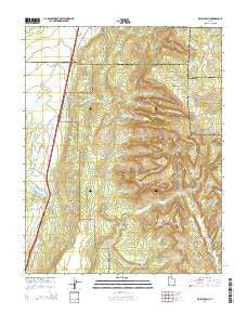
~ Kolob Arch UT topo map, 1:24000 scale, 7.5 X 7.5 Minute, Current, 2014
Kolob Arch, Utah, USGS topographic map dated 2014.
Includes geographic coordinates (latitude and longitude). This topographic map is suitable for hiking, camping, and exploring, or framing it as a wall map.
Printed on-demand using high resolution imagery, on heavy weight and acid free paper, or alternatively on a variety of synthetic materials.
Topos available on paper, Waterproof, Poly, or Tyvek. Usually shipping rolled, unless combined with other folded maps in one order.
- Product Number: USGS-7787163
- Free digital map download (high-resolution, GeoPDF): Kolob Arch, Utah (file size: 39 MB)
- Map Size: please refer to the dimensions of the GeoPDF map above
- Weight (paper map): ca. 55 grams
- Map Type: POD USGS Topographic Map
- Map Series: US Topo
- Map Verison: Current
- Cell ID: 23942
- Datum: North American Datum of 1983
- Map Projection: Transverse Mercator
- Map Cell Name: Kolob Arch
- Grid size: 7.5 X 7.5 Minute
- Date on map: 2014
- Map Scale: 1:24000
- Geographical region: Utah, United States
Neighboring Maps:
All neighboring USGS topo maps are available for sale online at a variety of scales.
Spatial coverage:
Topo map Kolob Arch, Utah, covers the geographical area associated the following places:
- Hop Valley - Kolob Arch Trail - Ash Creek Reservoir - Taylor Creek Wilderness - Old Fort Harmony (historical) - Locust Creek - Cane Creek - Larson Cabin - Wayne Canyon - Beatty Spring - Kolob Arch - Camp Creek - Timber Creek - Lee Pass - Taylor Creek - Beatty Point - Stapley Point - Herbs Point - Burnt Mountain - Nagunt Mesa - La Verkin Creek Trail - Epsolon Mine - Shuntavi Butte - Middle Fork Taylor Creek - Timber Top Mountain - Hop Valley Trail - Kolob Canyons Viewpoint - Deadman Hollow - New Harmony Fire Station - Kolob Station - Fort Harmony Monument - Gregory Butte - Death Point - Ash Creek Dam - Kolob Canyon Road Terminus Campground - Paria Point - North Fork Taylor Creek - Smith Cabin - Hurricane Cliffs - Black Ridge - Langston Canyon - Currant Creek - Neagle Ridge - Horse Ranch Mountain - Kolob Canyons Visitor Center - South Fork Taylor Creek - Pace Knoll - Buck Pasture Mountain - Tucupit Point
- Map Area ID: AREA37.537.375-113.25-113.125
- Northwest corner Lat/Long code: USGSNW37.5-113.25
- Northeast corner Lat/Long code: USGSNE37.5-113.125
- Southwest corner Lat/Long code: USGSSW37.375-113.25
- Southeast corner Lat/Long code: USGSSE37.375-113.125
- Northern map edge Latitude: 37.5
- Southern map edge Latitude: 37.375
- Western map edge Longitude: -113.25
- Eastern map edge Longitude: -113.125


