
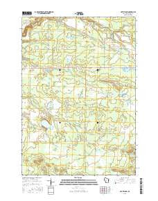
~ Hatfield SW WI topo map, 1:24000 scale, 7.5 X 7.5 Minute, 2015
Hatfield SW, Wisconsin, USGS topographic map dated 2015.
Includes geographic coordinates (latitude and longitude). This topographic map is suitable for hiking, camping, and exploring, or framing it as a wall map.
Printed on-demand using high resolution imagery, on heavy weight and acid free paper, or alternatively on a variety of synthetic materials.
Topos available on paper, Waterproof, Poly, or Tyvek. Usually shipping rolled, unless combined with other folded maps in one order.
- Product Number: USGS-7685100
- Free digital map download (high-resolution, GeoPDF): Hatfield SW, Wisconsin (file size: 25 MB)
- Map Size: please refer to the dimensions of the GeoPDF map above
- Weight (paper map): ca. 55 grams
- Map Type: POD USGS Topographic Map
- Map Series: US Topo
- Map Verison: Current
- Cell ID: 76507
- Datum: North American Datum of 1983
- Map Projection: Transverse Mercator
- Map Cell Name: Hatfield SW
- Grid size: 7.5 X 7.5 Minute
- Date on map: 2015
- Map Scale: 1:24000
- Geographical region: Wisconsin, United States
Neighboring Maps:
All neighboring USGS topo maps are available for sale online at a variety of scales.
Spatial coverage:
Topo map Hatfield SW, Wisconsin, covers the geographical area associated the following places:
- Oxbow Pond - Little Bear Flowage - Wilson Marsh Flowage - Black River State Forest - Trowe Marsh - Little Bear Flowage 3 - Big Bear Flowage - Black River Correctional Center - Dry Land Flowage - Black River Camp Picnic Area - Lower Wilson Marsh Flowage - Iron Mound (historical) - Funmaker Flowage - Bauer-Brockway Barrens State Natural Area - Town of Komensky - Wildcat Flowage - White Creek - Resettlement Administration 21 Dam - Resettlement Administration 20 Dam - Squaw Mound Flowage 4 - Trowe Drain - Squaw Mound - Squaw Mound Flowage - Teal Flowage 7 - Jackson County Iron Mine - Staffon Flowage - Teal Flowage - Resettlement Administration 29 2WP398 Dam - Wazee Lake - Komensky Station
- Map Area ID: AREA44.37544.25-90.75-90.625
- Northwest corner Lat/Long code: USGSNW44.375-90.75
- Northeast corner Lat/Long code: USGSNE44.375-90.625
- Southwest corner Lat/Long code: USGSSW44.25-90.75
- Southeast corner Lat/Long code: USGSSE44.25-90.625
- Northern map edge Latitude: 44.375
- Southern map edge Latitude: 44.25
- Western map edge Longitude: -90.75
- Eastern map edge Longitude: -90.625


