
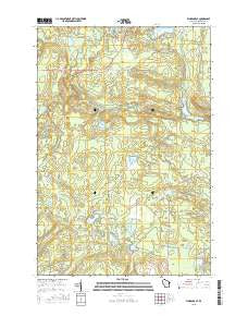
~ Florence SE WI topo map, 1:24000 scale, 7.5 X 7.5 Minute, 2015
Florence SE, Wisconsin, USGS topographic map dated 2015.
Includes geographic coordinates (latitude and longitude). This topographic map is suitable for hiking, camping, and exploring, or framing it as a wall map.
Printed on-demand using high resolution imagery, on heavy weight and acid free paper, or alternatively on a variety of synthetic materials.
Topos available on paper, Waterproof, Poly, or Tyvek. Usually shipping rolled, unless combined with other folded maps in one order.
- Product Number: USGS-7675700
- Free digital map download (high-resolution, GeoPDF): Florence SE, Wisconsin (file size: 25 MB)
- Map Size: please refer to the dimensions of the GeoPDF map above
- Weight (paper map): ca. 55 grams
- Map Type: POD USGS Topographic Map
- Map Series: US Topo
- Map Verison: Current
- Cell ID: 15616
- Datum: North American Datum of 1983
- Map Projection: Transverse Mercator
- Map Cell Name: Florence SE
- Grid size: 7.5 X 7.5 Minute
- Date on map: 2015
- Map Scale: 1:24000
- Geographical region: Wisconsin, United States
Neighboring Maps:
All neighboring USGS topo maps are available for sale online at a variety of scales.
Spatial coverage:
Topo map Florence SE, Wisconsin, covers the geographical area associated the following places:
- Sand Lake - Jutra Lake - West Bass Lake - Pine River Flowage - Pine River Flowage 543 - Woods Creek - Lamon Tangue Creek - Pine Rapids - Popple River - Town of Homestead - Pine River WP146 Dam - Lund Creek - Halls Lake - Sand Lake Branch - Scout Lake - Meyers Creek - Township of Fern Pit - Prairie School (historical) - Popple Rapids - Seidel Lake - Town of Fern - Marm Lake - Homestead Park - Buckskin Lake - Bass Lake Lookout Tower - Emily Lake - Mirror Lake - Pine River Dam - Bass Lake - Seidel Creek - Halls Creek Wildlife Flowage 3WR1799 Dam - Halls Creek - Halls Lake 4.95 - Bush Lake
- Map Area ID: AREA45.87545.75-88.375-88.25
- Northwest corner Lat/Long code: USGSNW45.875-88.375
- Northeast corner Lat/Long code: USGSNE45.875-88.25
- Southwest corner Lat/Long code: USGSSW45.75-88.375
- Southeast corner Lat/Long code: USGSSE45.75-88.25
- Northern map edge Latitude: 45.875
- Southern map edge Latitude: 45.75
- Western map edge Longitude: -88.375
- Eastern map edge Longitude: -88.25


