
~ Danbury West WI topo map, 1:24000 scale, 7.5 X 7.5 Minute, 2015
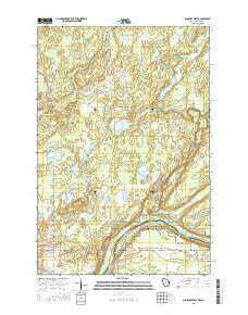
Danbury West, Wisconsin, USGS topographic map dated 2015.
Includes geographic coordinates (latitude and longitude). This topographic map is suitable for hiking, camping, and exploring, or framing it as a wall map.
Printed on-demand using high resolution imagery, on heavy weight and acid free paper, or alternatively on a variety of synthetic materials.
Topos available on paper, Waterproof, Poly, or Tyvek. Usually shipping rolled, unless combined with other folded maps in one order.
- Product Number: USGS-7673887
- Free digital map download (high-resolution, GeoPDF): Danbury West, Wisconsin (file size: 28 MB)
- Map Size: please refer to the dimensions of the GeoPDF map above
- Weight (paper map): ca. 55 grams
- Map Type: POD USGS Topographic Map
- Map Series: US Topo
- Map Verison: Current
- Cell ID: 11294
- Datum: North American Datum of 1983
- Map Projection: Transverse Mercator
- Map Cell Name: Danbury West
- Grid size: 7.5 X 7.5 Minute
- Date on map: 2015
- Map Scale: 1:24000
- Geographical region: Wisconsin, United States
Neighboring Maps:
All neighboring USGS topo maps are available for sale online at a variety of scales.
Spatial coverage:
Topo map Danbury West, Wisconsin, covers the geographical area associated the following places:
- Township of Wilma - Graces Lake - Native American Burial Grounds - Hanson Creek - Rock Lake - Lena Lake Chapel - Mille Lacs Tribal Police Department Sandstone - Danbury Census Designated Place - McDermott Creek - Ogema Cemetery - Jamar Scout Camp - Lena Lake Indian Center - Keene Lake - Stevens Lake - Horsemans Campground - Greigs Lake - Mallard Lake - Razor Lake - Mud Lake - Sangeta Creek - Saint Croix Camp - Hay Creek Flowage - Boulder Campground - Lower Tamarack River - Albrechts Creek - Markville Snowmobile Trail - Hay Creek Dam - Longstrem Brook - Township of Ogema - Lena Lake Cemetery - Hay Creek Reservoir - Benjamin Lake - Saint Croix Haven Campgrounds - Lena Lake - Saint Croix State Forest - Billys Lake - Churchill Lake - Hay Creek - Sutton Lake
- Map Area ID: AREA46.12546-92.5-92.375
- Northwest corner Lat/Long code: USGSNW46.125-92.5
- Northeast corner Lat/Long code: USGSNE46.125-92.375
- Southwest corner Lat/Long code: USGSSW46-92.5
- Southeast corner Lat/Long code: USGSSE46-92.375
- Northern map edge Latitude: 46.125
- Southern map edge Latitude: 46
- Western map edge Longitude: -92.5
- Eastern map edge Longitude: -92.375


