
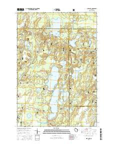
~ Pike Lake WI topo map, 1:24000 scale, 7.5 X 7.5 Minute, 2015
Pike Lake, Wisconsin, USGS topographic map dated 2015.
Includes geographic coordinates (latitude and longitude). This topographic map is suitable for hiking, camping, and exploring, or framing it as a wall map.
Printed on-demand using high resolution imagery, on heavy weight and acid free paper, or alternatively on a variety of synthetic materials.
Topos available on paper, Waterproof, Poly, or Tyvek. Usually shipping rolled, unless combined with other folded maps in one order.
- Product Number: USGS-7661434
- Free digital map download (high-resolution, GeoPDF): Pike Lake, Wisconsin (file size: 26 MB)
- Map Size: please refer to the dimensions of the GeoPDF map above
- Weight (paper map): ca. 55 grams
- Map Type: POD USGS Topographic Map
- Map Series: US Topo
- Map Verison: Current
- Cell ID: 35132
- Datum: North American Datum of 1983
- Map Projection: Transverse Mercator
- Map Cell Name: Pike Lake
- Grid size: 7.5 X 7.5 Minute
- Date on map: 2015
- Map Scale: 1:24000
- Geographical region: Wisconsin, United States
Neighboring Maps:
All neighboring USGS topo maps are available for sale online at a variety of scales.
Spatial coverage:
Topo map Pike Lake, Wisconsin, covers the geographical area associated the following places:
- Foulds Creek - Spring Branch - Pike Lake - Twin Lakes - Big Pine Lake - Sentinal Point Lookout Tower - Emily Lake Campground - Deer Lake - Round Lake - Springstead Creek - Little Pine Creek - Emily Lake - Wabasso Lake - Pond Lake - Ferry Springs - Tucker Lake Hemlocks State Natural Area - Tucker Creek - Thompson Creek - Rice Lake Creek - Caro Timber Picnic Ground (historical) - Bass Lake Preserve State Natural Area - Oles Lake - Squaw Creek - Miles Lake - Pike Lake Fire Department - Cochran Creek - Twin Lakes Campground - Turner Lake - Jupa Lake - Pine Creek - Townline Lake - Tucker Lake - Rice Lake - McArthur Lake - Memorial Grove Picnic Area - Rice Creek - Memorial Grove Hemlocks State Natural Area - Cochran Lake - Emily Creek - Tackle Lake - Fishtrap Campground - Amik Lake - Duck Lake - Apeekwa Lake - Franks Seaplane Base
- Map Area ID: AREA4645.875-90.125-90
- Northwest corner Lat/Long code: USGSNW46-90.125
- Northeast corner Lat/Long code: USGSNE46-90
- Southwest corner Lat/Long code: USGSSW45.875-90.125
- Southeast corner Lat/Long code: USGSSE45.875-90
- Northern map edge Latitude: 46
- Southern map edge Latitude: 45.875
- Western map edge Longitude: -90.125
- Eastern map edge Longitude: -90


