
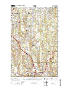
~ Bothell WA topo map, 1:24000 scale, 7.5 X 7.5 Minute, Current, 2014
Bothell, Washington, USGS topographic map dated 2014.
Includes geographic coordinates (latitude and longitude). This topographic map is suitable for hiking, camping, and exploring, or framing it as a wall map.
Printed on-demand using high resolution imagery, on heavy weight and acid free paper, or alternatively on a variety of synthetic materials.
Topos available on paper, Waterproof, Poly, or Tyvek. Usually shipping rolled, unless combined with other folded maps in one order.
- Product Number: USGS-7529053
- Free digital map download (high-resolution, GeoPDF): Bothell, Washington (file size: 31 MB)
- Map Size: please refer to the dimensions of the GeoPDF map above
- Weight (paper map): ca. 55 grams
- Map Type: POD USGS Topographic Map
- Map Series: US Topo
- Map Verison: Current
- Cell ID: 4944
- Datum: North American Datum of 1983
- Map Projection: Transverse Mercator
- Map Cell Name: Bothell
- Grid size: 7.5 X 7.5 Minute
- Date on map: 2014
- Map Scale: 1:24000
- Geographical region: Washington, United States
Neighboring Maps:
All neighboring USGS topo maps are available for sale online at a variety of scales.
Spatial coverage:
Topo map Bothell, Washington, covers the geographical area associated the following places:
- Wintermutes Corner - Holly Hills Mobile Home Park - Day City (historical) - Valley View Mobile Manor - Lake Terrace Court Mobile Home Park - Martha Lake Mobile Manor - Twin Creek Mobile Home Park - River Shores Mobile Home Park - Thrashers Corner - Sarvis Mobile Estates - Canyon Recreational Vehicle Park - Woodinville - Mill Creek - Sherwood Village Mobile Home Park - North Creek Mobile Home Park - Kennard Mobile Estates - Bothell - Turner Corner - Cascade Vista Mobile Estates - Clearview - Lakewood Villa Mobile Home Park - Silver Firs - Country Carriage Estates Mobile Home Park - Lazy Wheels Mobile Park - North Creek - Lakewood Mobile Home Park - Lockwood Village Mobile Home Park - Grace - Royal Coachman Mobile Home Park - Green Acres Mobile Home Park - Riverside Mobile Estates - Canterbury Square Mobile Home Park - Canyon Park - Inglewood Estates Mobile Home Park - Canyon Mobile Park - Woodcrest Estates Mobile Home Park - Martha Lake - Kenmore - Northwest Mobile Home Park - Kennard Corner - Halo Mobile Home Park - Thunderbird Mobile Home Park
- Map Area ID: AREA47.87547.75-122.25-122.125
- Northwest corner Lat/Long code: USGSNW47.875-122.25
- Northeast corner Lat/Long code: USGSNE47.875-122.125
- Southwest corner Lat/Long code: USGSSW47.75-122.25
- Southeast corner Lat/Long code: USGSSE47.75-122.125
- Northern map edge Latitude: 47.875
- Southern map edge Latitude: 47.75
- Western map edge Longitude: -122.25
- Eastern map edge Longitude: -122.125


