
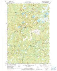
~ Pike Lake NW WI topo map, 1:24000 scale, 7.5 X 7.5 Minute, Historical, 1971, updated 1991
Pike Lake NW, Wisconsin, USGS topographic map dated 1971.
Includes geographic coordinates (latitude and longitude). This topographic map is suitable for hiking, camping, and exploring, or framing it as a wall map.
Printed on-demand using high resolution imagery, on heavy weight and acid free paper, or alternatively on a variety of synthetic materials.
Topos available on paper, Waterproof, Poly, or Tyvek. Usually shipping rolled, unless combined with other folded maps in one order.
- Product Number: USGS-6005903
- Free digital map download (high-resolution, GeoPDF): Pike Lake NW, Wisconsin (file size: 11 MB)
- Map Size: please refer to the dimensions of the GeoPDF map above
- Weight (paper map): ca. 55 grams
- Map Type: POD USGS Topographic Map
- Map Series: HTMC
- Map Verison: Historical
- Cell ID: 35134
- Scan ID: 800097
- Imprint Year: 1991
- Woodland Tint: Yes
- Photo Inspection Year: 1981
- Aerial Photo Year: 1969
- Field Check Year: 1971
- Datum: NAD27
- Map Projection: Polyconic
- Map published by United States Geological Survey
- Map Language: English
- Scanner Resolution: 508 dpi
- Map Cell Name: Pike Lake NW
- Grid size: 7.5 X 7.5 Minute
- Date on map: 1971
- Map Scale: 1:24000
- Geographical region: Wisconsin, United States
Neighboring Maps:
All neighboring USGS topo maps are available for sale online at a variety of scales.
Spatial coverage:
Topo map Pike Lake NW, Wisconsin, covers the geographical area associated the following places:
- Newman Lake - Beaver Creek - Smith River Campground - Thompson Lake - Cedar Rapids - Little Cedar Rapids - Marty Lake - Camp Four Springs - South Fork Fire Tower (historical) - Penny Lake - Newman Lake Recreation Area - Camp Nine Springs - Nettie B Lake - Newman Springs Ski Trail - Byhre Lake - Newman Creek - Robert Sells Flowage 1 - Riley Creek - Elevenmile Creek - Springstead Airport - South Lake - Clover Creek - Smith Rapids - Camp C Creek - Island Lake - Quimette Lake - Whitcomb Lake - Robert Sells 3WR814 Dam - Newman Springs - Kabol Lake - Riley Creek Forest Service Station - Shady Knoll School (historical) - Patterson Lake - Byhre Creek
- Map Area ID: AREA4645.875-90.25-90.125
- Northwest corner Lat/Long code: USGSNW46-90.25
- Northeast corner Lat/Long code: USGSNE46-90.125
- Southwest corner Lat/Long code: USGSSW45.875-90.25
- Southeast corner Lat/Long code: USGSSE45.875-90.125
- Northern map edge Latitude: 46
- Southern map edge Latitude: 45.875
- Western map edge Longitude: -90.25
- Eastern map edge Longitude: -90.125


