
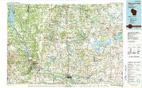
~ Wisconsin Dells WI topo map, 1:100000 scale, 30 X 60 Minute, Historical, 1990, updated 1991
Wisconsin Dells, Wisconsin, USGS topographic map dated 1990.
Includes geographic coordinates (latitude and longitude). This topographic map is suitable for hiking, camping, and exploring, or framing it as a wall map.
Printed on-demand using high resolution imagery, on heavy weight and acid free paper, or alternatively on a variety of synthetic materials.
Topos available on paper, Waterproof, Poly, or Tyvek. Usually shipping rolled, unless combined with other folded maps in one order.
- Product Number: USGS-6001188
- Free digital map download (high-resolution, GeoPDF): Wisconsin Dells, Wisconsin (file size: 19 MB)
- Map Size: please refer to the dimensions of the GeoPDF map above
- Weight (paper map): ca. 55 grams
- Map Type: POD USGS Topographic Map
- Map Series: HTMC
- Map Verison: Historical
- Cell ID: 68610
- Scan ID: 503696
- Imprint Year: 1991
- Woodland Tint: Yes
- Aerial Photo Year: 1986
- Edit Year: 1990
- Datum: NAD27
- Map Projection: Universal Transverse Mercator
- Map published by United States Geological Survey
- Map Language: English
- Scanner Resolution: 508 dpi
- Map Cell Name: Wisconsin Dells
- Grid size: 30 X 60 Minute
- Date on map: 1990
- Map Scale: 1:100000
- Geographical region: Wisconsin, United States
Neighboring Maps:
All neighboring USGS topo maps are available for sale online at a variety of scales.
Spatial coverage:
Topo map Wisconsin Dells, Wisconsin, covers the geographical area associated the following places:
- Marcellon - Green Lake Terrace - Friesland - Plainville - Baders Villa Estates - Grand Marsh - Lawrence - Packwaukee - Manchester - Mecan - Buffalo Shore Estates - Dellwood - Cambria - Douglas Center - Westfield - Brooks - Endeavor - Neshkoro - Belle Fountain - Sylvan Shores - Dakota - Bannerman - Ingle - Pardeeville - Oxford - Anacker - Kingston - Indian Heights - Princeton - Adams - Brookside - White Creek - Harrisville - Quincy (historical) - Germania - Budsin - Randolph - Lyndon Station - Briggsville - Rodney (historical) - Portage - Easton - Fairburn - Wisconsin Dells - Dell Prairie (historical) - Deer Run Estates - East Friesland - Lake Delton - Fordham (historical) - Springbluff (historical) - Big Spring - Greenwyck - The Courtyards - Marquette - Lewiston - Pilot Knob (historical) - New Chester (historical) - Greens Corners - Lakewood Estates - Friendship - Montello - Adams Center (historical) - Dalton - Glen Oak - Moe Settlement (historical) - Maple Aire Mobile Village - Dellwood
- Map Area ID: AREA4443.5-90-89
- Northwest corner Lat/Long code: USGSNW44-90
- Northeast corner Lat/Long code: USGSNE44-89
- Southwest corner Lat/Long code: USGSSW43.5-90
- Southeast corner Lat/Long code: USGSSE43.5-89
- Northern map edge Latitude: 44
- Southern map edge Latitude: 43.5
- Western map edge Longitude: -90
- Eastern map edge Longitude: -89


