
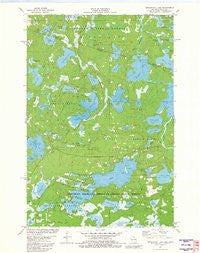
~ Tenderfoot Lake WI topo map, 1:24000 scale, 7.5 X 7.5 Minute, Historical, 1981, updated 1982
Tenderfoot Lake, Wisconsin, USGS topographic map dated 1981.
Includes geographic coordinates (latitude and longitude). This topographic map is suitable for hiking, camping, and exploring, or framing it as a wall map.
Printed on-demand using high resolution imagery, on heavy weight and acid free paper, or alternatively on a variety of synthetic materials.
Topos available on paper, Waterproof, Poly, or Tyvek. Usually shipping rolled, unless combined with other folded maps in one order.
- Product Number: USGS-6000722
- Free digital map download (high-resolution, GeoPDF): Tenderfoot Lake, Wisconsin (file size: 9 MB)
- Map Size: please refer to the dimensions of the GeoPDF map above
- Weight (paper map): ca. 55 grams
- Map Type: POD USGS Topographic Map
- Map Series: HTMC
- Map Verison: Historical
- Cell ID: 44547
- Scan ID: 502008
- Imprint Year: 1982
- Woodland Tint: Yes
- Aerial Photo Year: 1976
- Edit Year: 1981
- Field Check Year: 1978
- Datum: NAD27
- Map Projection: Lambert Conformal Conic
- Map published by United States Geological Survey
- Map Language: English
- Scanner Resolution: 508 dpi
- Map Cell Name: Tenderfoot Lake
- Grid size: 7.5 X 7.5 Minute
- Date on map: 1981
- Map Scale: 1:24000
- Geographical region: Wisconsin, United States
Neighboring Maps:
All neighboring USGS topo maps are available for sale online at a variety of scales.
Spatial coverage:
Topo map Tenderfoot Lake, Wisconsin, covers the geographical area associated the following places:
- Johnson Lake - Morton Lake - Notre Dame Church - Elizabeth Lake - Moosehead Lake - Lone Pine Lake - Cranberry Lake - Fishtrap Lake - Dunn Lake - Bambi Lake - Mud Lake - Jute Lake - Siphon Creek - Dorothy Lake - Little Presque Isle Lake - Russet Lake - Bergner Lake - Moosehead Lake Campground - Cochran Lake - Frog Island - McCullough Lake - Big Kitten Lake - Beaver Lake - High Lake - Hummingbird Lake - High Lake Spruce-Balsam Forest State Natural Area - Moccasin Lake - Dunn Lake State Natural Area - Roach Lake - Grassy Creek - Winifred Lake - Big Gibson Lake - Garland Creek - Sanborn Lake - Plum Lake - Corrine Lake - Sime Lake - Mirror Lake - Johnson Lake Barrens State Natural Area - Richard Lake - Edith Lake - Salsich Creek - Twilight Lake - Twin Island Lake - Wildcat Lake - Tenderfoot Lake - Killarney Point - Inkpot Lake - Devils Lake - Little Jute Lake - Little Gibson Lake - Nansen Lake - Presque Springs - Jones Lake - Oswego Lake - Plum Lake - Minnie Lake - Rush Lake - Grassy Lake
- Map Area ID: AREA46.2546.125-89.625-89.5
- Northwest corner Lat/Long code: USGSNW46.25-89.625
- Northeast corner Lat/Long code: USGSNE46.25-89.5
- Southwest corner Lat/Long code: USGSSW46.125-89.625
- Southeast corner Lat/Long code: USGSSE46.125-89.5
- Northern map edge Latitude: 46.25
- Southern map edge Latitude: 46.125
- Western map edge Longitude: -89.625
- Eastern map edge Longitude: -89.5


