
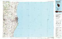
~ Sheboygan WI topo map, 1:100000 scale, 30 X 60 Minute, Historical, 1989, updated 1990
Sheboygan, Wisconsin, USGS topographic map dated 1989.
Includes geographic coordinates (latitude and longitude). This topographic map is suitable for hiking, camping, and exploring, or framing it as a wall map.
Printed on-demand using high resolution imagery, on heavy weight and acid free paper, or alternatively on a variety of synthetic materials.
Topos available on paper, Waterproof, Poly, or Tyvek. Usually shipping rolled, unless combined with other folded maps in one order.
- Product Number: USGS-6000394
- Free digital map download (high-resolution, GeoPDF): Sheboygan, Wisconsin (file size: 20 MB)
- Map Size: please refer to the dimensions of the GeoPDF map above
- Weight (paper map): ca. 55 grams
- Map Type: POD USGS Topographic Map
- Map Series: HTMC
- Map Verison: Historical
- Cell ID: 68354
- Scan ID: 503682
- Imprint Year: 1990
- Woodland Tint: Yes
- Aerial Photo Year: 1981
- Edit Year: 1989
- Datum: NAD27
- Map Projection: Universal Transverse Mercator
- Map published by United States Geological Survey
- Map Language: English
- Scanner Resolution: 508 dpi
- Map Cell Name: Sheboygan
- Grid size: 30 X 60 Minute
- Date on map: 1989
- Map Scale: 1:100000
- Geographical region: Wisconsin, United States
Neighboring Maps:
All neighboring USGS topo maps are available for sale online at a variety of scales.
Spatial coverage:
Topo map Sheboygan, Wisconsin, covers the geographical area associated the following places:
- Adell - Cedar Grove - New Paris - Cleveland - Northeim - Waldo - Sommer's Woodhaven Mobile Home Park - Sheboygan - Dacada - Rhine - Nenning Mobile Home Park - Louis Corners - Sauk Trail Beach - Howards Grove - Newton - Haven - Erdman - Osman - Ada - Kennedys Corners (historical) - Plymouth - Acacia Falls Mobile Home Court - Random Lake - Ourtown - Gibbsville - Edwards - Millhome - Mosel - Indian Meadows - Cleveland Heights Mobile Home Park - Spring Valley - Oostburg - Meeme - Sheboygan Falls - Hayen - School Hill - Franklin - Johnsonville - Hingham - Kohler - Idlewood Beach - Weedens - Plymouth Country View Estates - Rockville
- Map Area ID: AREA4443.5-88-87
- Northwest corner Lat/Long code: USGSNW44-88
- Northeast corner Lat/Long code: USGSNE44-87
- Southwest corner Lat/Long code: USGSSW43.5-88
- Southeast corner Lat/Long code: USGSSE43.5-87
- Northern map edge Latitude: 44
- Southern map edge Latitude: 43.5
- Western map edge Longitude: -88
- Eastern map edge Longitude: -87


