
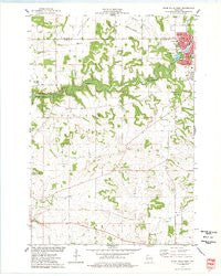
~ River Falls West WI topo map, 1:24000 scale, 7.5 X 7.5 Minute, Historical, 1974, updated 1977
River Falls West, Wisconsin, USGS topographic map dated 1974.
Includes geographic coordinates (latitude and longitude). This topographic map is suitable for hiking, camping, and exploring, or framing it as a wall map.
Printed on-demand using high resolution imagery, on heavy weight and acid free paper, or alternatively on a variety of synthetic materials.
Topos available on paper, Waterproof, Poly, or Tyvek. Usually shipping rolled, unless combined with other folded maps in one order.
- Product Number: USGS-6000226
- Free digital map download (high-resolution, GeoPDF): River Falls West, Wisconsin (file size: 7 MB)
- Map Size: please refer to the dimensions of the GeoPDF map above
- Weight (paper map): ca. 55 grams
- Map Type: POD USGS Topographic Map
- Map Series: HTMC
- Map Verison: Historical
- Cell ID: 38030
- Scan ID: 501784
- Imprint Year: 1977
- Woodland Tint: Yes
- Aerial Photo Year: 1973
- Field Check Year: 1974
- Datum: NAD27
- Map Projection: Lambert Conformal Conic
- Map published by United States Geological Survey
- Map Language: English
- Scanner Resolution: 508 dpi
- Map Cell Name: River Falls West
- Grid size: 7.5 X 7.5 Minute
- Date on map: 1974
- Map Scale: 1:24000
- Geographical region: Wisconsin, United States
Neighboring Maps:
All neighboring USGS topo maps are available for sale online at a variety of scales.
Spatial coverage:
Topo map River Falls West, Wisconsin, covers the geographical area associated the following places:
- Clifton Hollow School (historical) - Wells Park - Yorks Mound - Saint Bridget Cemetery - Glen Park - Prucha Hall - Riverside Square Shopping Mall - Greenwood Valley Cemetery - Lone Mound - Clifton Highlands Golf Course - Clifton Hollow Golf Club - Glass Valley School (historical) - Sunnyside School (historical) - Glen Park Municipal Swimming Pool - Junction Falls Dam - Clifton Townhall - Oak Knoll School (historical) - Pierce Valley School (historical) - Melander Hill - South Fork Kinnickinnic River - Stratton Hall - West Dale Park - Rocky Branch Elementary School - Town of Clifton - Upper Kinnickinnic Pond - Apostolic Church - Mann Valley - Westside Elementary School - Ingram Center - Tegeler Airport (historical) - Kinnickinnic State Park - Hillcrest Rest Home - River Falls Public Montessori Academy - Rocky Branch - Mann Valley Church (historical) - Sand Hill School (historical) - Johnson Hall - Renaissance Charter Academy - Angel Hill School (historical) - Hagestad Student Center - Mann Valley Cemetery - Ashbaugh Mound - Powell Falls 2WP180 Dam - May Hall - Lafette School (historical) - Big River Presbyterian Cemetery - Lower Kinnickinnic Pond - Tower Park
- Map Area ID: AREA44.87544.75-92.75-92.625
- Northwest corner Lat/Long code: USGSNW44.875-92.75
- Northeast corner Lat/Long code: USGSNE44.875-92.625
- Southwest corner Lat/Long code: USGSSW44.75-92.75
- Southeast corner Lat/Long code: USGSSE44.75-92.625
- Northern map edge Latitude: 44.875
- Southern map edge Latitude: 44.75
- Western map edge Longitude: -92.75
- Eastern map edge Longitude: -92.625


