
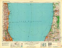
~ Racine WI topo map, 1:250000 scale, 1 X 2 Degree, Historical, 1962, updated 1962
Racine, Wisconsin, USGS topographic map dated 1962.
Includes geographic coordinates (latitude and longitude). This topographic map is suitable for hiking, camping, and exploring, or framing it as a wall map.
Printed on-demand using high resolution imagery, on heavy weight and acid free paper, or alternatively on a variety of synthetic materials.
Topos available on paper, Waterproof, Poly, or Tyvek. Usually shipping rolled, unless combined with other folded maps in one order.
- Product Number: USGS-6000088
- Free digital map download (high-resolution, GeoPDF): Racine, Wisconsin (file size: 7 MB)
- Map Size: please refer to the dimensions of the GeoPDF map above
- Weight (paper map): ca. 55 grams
- Map Type: POD USGS Topographic Map
- Map Series: HTMC
- Map Verison: Historical
- Cell ID: 68980
- Scan ID: 503699
- Imprint Year: 1962
- Woodland Tint: Yes
- Aerial Photo Year: 1956
- Field Check Year: 1958
- Datum: Unstated
- Map Projection: Transverse Mercator
- Map published by United States Army Corps of Engineers
- Map published by United States Army
- Map Language: English
- Scanner Resolution: 508 dpi
- Map Cell Name: Racine
- Grid size: 1 X 2 Degree
- Date on map: 1962
- Map Scale: 1:250000
- Geographical region: Wisconsin, United States
Neighboring Maps:
All neighboring USGS topo maps are available for sale online at a variety of scales.
Spatial coverage:
Topo map Racine, Wisconsin, covers the geographical area associated the following places:
- Northbrook Heights - Highland Park - Braywood - Agnew - Maple Grove Corners - Grandwood Park - Wildwood - Florian - Lee Woods - Cobblewood - Shermer Ridge - Somers - Villas North - Wilshire Terrace - Oak Grove - Porter Subdivision - South Haven Highlands - Noordeloos - Del Mar Woods - Citation Lake - State Line - Heart O' Northbrook - Beachmont - Saint Francis - Crystal Mobile Home Park - Breedsville - Ramsgate South - Anetsberger's Subdivision - Saugatuck - Vineland - Deerfield - Stonebrook East - Glenn Stores - Driftwood - Westfield - Wood Oaks Glen - Ives - Racine - Graafschap - Waverly Shores Village Mobile Home Park - Dolands Addition - Keeler - Northbrook Estates - The Willows - Waukegan - Wildwood - Benton Heights - Norma - Friendsville - Spring Grove - Maple Ridge - Rozenow's Subdivision - Pullman - Villas West - Loveland's Subdivision - Sunset Fields - Hawkhead - Linden Hills - Mobile Village Trailer Park - Weller's Subdivision - Skiersch's Subdivision - Beach Station - Lake Forest - Winschester Lane North - Slocum Corners - Pearl - Mount Prospect - Star Subdivision - Spring Lake Mobile Home Park - Fox Hedge - Kennedy - Windham - Willow Woods - Naomi - Borculo - Riverside - Bridlewood Lane - Skokie Junction - Northbrook Acres - Kings Landing - Sodus - Hollywood - Horatio Gardens - Edgewood Grove - Rogers Park - Charring Cross - Bainbridge Center - Sportmans Cove - Vernon Hills - Kelley Corners - Beechwood - Lee Acres - Grace Manor - Lacota - Waxdale - Oakton - Riverview - Spaulding Corners - Northfield Woods - Brockdale Manor
- Map Area ID: AREA4342-88-86
- Northwest corner Lat/Long code: USGSNW43-88
- Northeast corner Lat/Long code: USGSNE43-86
- Southwest corner Lat/Long code: USGSSW42-88
- Southeast corner Lat/Long code: USGSSE42-86
- Northern map edge Latitude: 43
- Southern map edge Latitude: 42
- Western map edge Longitude: -88
- Eastern map edge Longitude: -86


