
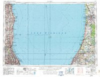
~ Racine WI topo map, 1:250000 scale, 1 X 2 Degree, Historical, 1958, updated 1986
Racine, Wisconsin, USGS topographic map dated 1958.
Includes geographic coordinates (latitude and longitude). This topographic map is suitable for hiking, camping, and exploring, or framing it as a wall map.
Printed on-demand using high resolution imagery, on heavy weight and acid free paper, or alternatively on a variety of synthetic materials.
Topos available on paper, Waterproof, Poly, or Tyvek. Usually shipping rolled, unless combined with other folded maps in one order.
- Product Number: USGS-6000086
- Free digital map download (high-resolution, GeoPDF): Racine, Wisconsin (file size: 17 MB)
- Map Size: please refer to the dimensions of the GeoPDF map above
- Weight (paper map): ca. 55 grams
- Map Type: POD USGS Topographic Map
- Map Series: HTMC
- Map Verison: Historical
- Cell ID: 68980
- Scan ID: 503698
- Imprint Year: 1986
- Woodland Tint: Yes
- Aerial Photo Year: 1981
- Edit Year: 1983
- Field Check Year: 1958
- Datum: NAD27
- Map Projection: Transverse Mercator
- Map published by United States Geological Survey
- Map Language: English
- Scanner Resolution: 508 dpi
- Map Cell Name: Racine
- Grid size: 1 X 2 Degree
- Date on map: 1958
- Map Scale: 1:250000
- Geographical region: Wisconsin, United States
Neighboring Maps:
All neighboring USGS topo maps are available for sale online at a variety of scales.
Spatial coverage:
Topo map Racine, Wisconsin, covers the geographical area associated the following places:
- Woodland Beach - Derby - Bainbridge Center - Half Day - Manus North Shore Estates - Millburg - Northfield Acres - Melody - Glenbrook Acres West - Lawrence Mobile Home Park - Weller's Subdivision - Glenn Shores - Williamsburg Square - Douglas - Phelps Mobile Home Park - Jensen's Mobile Home Village - Heart O' Northbrook - Gibson - Birch Pond - Schnells Corner - Hartman - Cobblewood - Willows North - Shorecrest Pointe - Kenosha - Briergate - Whispering Pines Estates and Mobile Home Park - Edgewood Grove - Beechwood - Glenn - Lakeshire - Colonial Village - Willow Cove - Willowbrook Acres - Grand Junction - Ravine View Estates Mobile Home Park - Hollywood - Kingsport Court - Racine - Mount Pleasant - Spring Grove - Bushs Corners - Sportmans Cove - Mitchell Brothers Mobile Home Park - Dundee Road Acres - Winnetka - Willow Park Mobile Home Park - Miami Park - Meadow Green - Dorothy Stirling Subdivision - East Saugatuck - Porters Glenview Subdivision - Maple Island - Morton Grove - Ravinia - Franksville - Summerhill - Villas of Northbrook - Northfield - Coloma - Indian Creek - Huntington - Wilmette - Red Haw Ridge - Oxbow - Marlen Subdivision - Pleasant View Estates Mobile Home Park - Fossland - Wildebrook On The Green - Timber Ridge - Chittenden - Windham Manor - Northway - Truesdell - Linden Ridge - Glen Lord - The Colonnades - Five Mile Corners - Pleasant Prairie Mobile Home Court - Hamilton - Alpine Village Mobile Home Park - Mettawa - Innisfail - Moran Corners - Country Acres Mobile Home Park - Dunn Corners - Sulphur Springs - Salceca North - Scottdale - Dunes Park - Meadow Streams Estate Mobile Home Park - Rusk - Hubbard Woods - Breedsville - Charring Cross - West Lake Forest - Covenant Village - Shanghai Corners - Lincoln Estates Mobile Home Park - Ganges
- Map Area ID: AREA4342-88-86
- Northwest corner Lat/Long code: USGSNW43-88
- Northeast corner Lat/Long code: USGSNE43-86
- Southwest corner Lat/Long code: USGSSW42-88
- Southeast corner Lat/Long code: USGSSE42-86
- Northern map edge Latitude: 43
- Southern map edge Latitude: 42
- Western map edge Longitude: -88
- Eastern map edge Longitude: -86


