
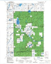
~ Park Falls NE WI topo map, 1:24000 scale, 7.5 X 7.5 Minute, Historical, 1968, updated 1985
Park Falls NE, Wisconsin, USGS topographic map dated 1968.
Includes geographic coordinates (latitude and longitude). This topographic map is suitable for hiking, camping, and exploring, or framing it as a wall map.
Printed on-demand using high resolution imagery, on heavy weight and acid free paper, or alternatively on a variety of synthetic materials.
Topos available on paper, Waterproof, Poly, or Tyvek. Usually shipping rolled, unless combined with other folded maps in one order.
- Product Number: USGS-5999788
- Free digital map download (high-resolution, GeoPDF): Park Falls NE, Wisconsin (file size: 10 MB)
- Map Size: please refer to the dimensions of the GeoPDF map above
- Weight (paper map): ca. 55 grams
- Map Type: POD USGS Topographic Map
- Map Series: HTMC
- Map Verison: Historical
- Cell ID: 4403
- Scan ID: 501728
- Imprint Year: 1985
- Woodland Tint: Yes
- Aerial Photo Year: 1981
- Edit Year: 1983
- Field Check Year: 1968
- Datum: NAD27
- Map Projection: Polyconic
- Interim map: Yes
- Map published by United States Geological Survey
- Map Language: English
- Scanner Resolution: 508 dpi
- Map Cell Name: Blockhouse Lake
- Grid size: 7.5 X 7.5 Minute
- Date on map: 1968
- Map Scale: 1:24000
- Geographical region: Wisconsin, United States
Neighboring Maps:
All neighboring USGS topo maps are available for sale online at a variety of scales.
Spatial coverage:
Topo map Park Falls NE, Wisconsin, covers the geographical area associated the following places:
- Hansen Lake - Hay Creek - Bear Lake - The Ledge Rapids - Granger Lake - East Fork Hay Creek - Cedar Creek - Wintergreen Lake - Hay Lake - Threemile Creek - Bullhead Lake - Third Rapids - Tracy Creek - Iodine Lake - Hoffman Creek - Flambeau Trails Parking Area - Tracy Lake - Lost Lake - Planet Lake - Sugarbush School (historical) - WHBM-FM (Park Falls) - Sugarbush Dam - Hay Creek Hoffman Lake State Wildlife Area - WLEF-TV (Park Falls) - Pershing School (historical) - Forest Rapids - Creeds Flowage - Fifield Lookout Tower - Beaverdam Lake - Sixth Rapids - Hoffman Lake - Blockhouse Lake - Fifth Rapids - Town of Eisenstein - Fourth Rapids
- Map Area ID: AREA4645.875-90.375-90.25
- Northwest corner Lat/Long code: USGSNW46-90.375
- Northeast corner Lat/Long code: USGSNE46-90.25
- Southwest corner Lat/Long code: USGSSW45.875-90.375
- Southeast corner Lat/Long code: USGSSE45.875-90.25
- Northern map edge Latitude: 46
- Southern map edge Latitude: 45.875
- Western map edge Longitude: -90.375
- Eastern map edge Longitude: -90.25


