
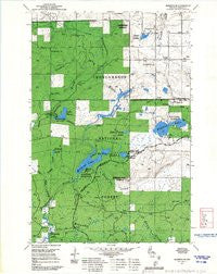
~ Marengo SE WI topo map, 1:24000 scale, 7.5 X 7.5 Minute, Historical, 1967
Marengo SE, Wisconsin, USGS topographic map dated 1967.
Includes geographic coordinates (latitude and longitude). This topographic map is suitable for hiking, camping, and exploring, or framing it as a wall map.
Printed on-demand using high resolution imagery, on heavy weight and acid free paper, or alternatively on a variety of synthetic materials.
Topos available on paper, Waterproof, Poly, or Tyvek. Usually shipping rolled, unless combined with other folded maps in one order.
- Product Number: USGS-5999046
- Free digital map download (high-resolution, GeoPDF): Marengo SE, Wisconsin (file size: 9 MB)
- Map Size: please refer to the dimensions of the GeoPDF map above
- Weight (paper map): ca. 55 grams
- Map Type: POD USGS Topographic Map
- Map Series: HTMC
- Map Verison: Historical
- Cell ID: 29515
- Scan ID: 501726
- Woodland Tint: Yes
- Aerial Photo Year: 1965
- Field Check Year: 1967
- Datum: NAD27
- Map Projection: Polyconic
- Map published by United States Geological Survey
- Map published by United States Forest Service
- Map Language: English
- Scanner Resolution: 508 dpi
- Map Cell Name: Mineral Lake
- Grid size: 7.5 X 7.5 Minute
- Date on map: 1967
- Map Scale: 1:24000
- Geographical region: Wisconsin, United States
Neighboring Maps:
All neighboring USGS topo maps are available for sale online at a variety of scales.
Spatial coverage:
Topo map Marengo SE, Wisconsin, covers the geographical area associated the following places:
- Beaverdam Lake - Camp Six Creek - Bass Lake - Lake Three 2WP433 Dam - Mineral Lake Recreation Site - Martin Hanson G963 10 Dam - Brunsweiler Creek 2WP613 Dam - Frames Creek - English Lake - McCarthy Creek - Pine Stump Corner - Waboo Creek - Lake Three Recreation Site - Toskis Creek - Gilbert Lake - Spider and Moquah Lakes 19 - Lake Three - Mineral Lake - Lake Three 1 - Mineral Lake Lookout Tower - Hudson Bay 3WR232 Dam - 0.2 Reservoir - Chequamegon Hardwoods State Natural Area - Beaverdam Lake 36 - John Frank Lake - 0.23 Reservoir - Town of Marengo - Marengo Lookout Tower - Gogebic Range - Potter Lake Recreation Site - Spring Brook - Hell Hole Creek - Uihlein 3NW81804 Dam - Potter Lake
- Map Area ID: AREA46.37546.25-90.875-90.75
- Northwest corner Lat/Long code: USGSNW46.375-90.875
- Northeast corner Lat/Long code: USGSNE46.375-90.75
- Southwest corner Lat/Long code: USGSSW46.25-90.875
- Southeast corner Lat/Long code: USGSSE46.25-90.75
- Northern map edge Latitude: 46.375
- Southern map edge Latitude: 46.25
- Western map edge Longitude: -90.875
- Eastern map edge Longitude: -90.75


