
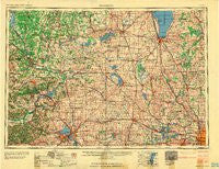
~ Madison WI topo map, 1:250000 scale, 1 X 2 Degree, Historical, 1960, updated 1960
Madison, Wisconsin, USGS topographic map dated 1960.
Includes geographic coordinates (latitude and longitude). This topographic map is suitable for hiking, camping, and exploring, or framing it as a wall map.
Printed on-demand using high resolution imagery, on heavy weight and acid free paper, or alternatively on a variety of synthetic materials.
Topos available on paper, Waterproof, Poly, or Tyvek. Usually shipping rolled, unless combined with other folded maps in one order.
- Product Number: USGS-5998974
- Free digital map download (high-resolution, GeoPDF): Madison, Wisconsin (file size: 12 MB)
- Map Size: please refer to the dimensions of the GeoPDF map above
- Weight (paper map): ca. 55 grams
- Map Type: POD USGS Topographic Map
- Map Series: HTMC
- Map Verison: Historical
- Cell ID: 68887
- Scan ID: 503707
- Imprint Year: 1960
- Woodland Tint: Yes
- Aerial Photo Year: 1955
- Field Check Year: 1957
- Datum: Unstated
- Map Projection: Transverse Mercator
- Map published by United States Army Corps of Engineers
- Map published by United States Army
- Map Language: English
- Scanner Resolution: 508 dpi
- Map Cell Name: Madison
- Grid size: 1 X 2 Degree
- Date on map: 1960
- Map Scale: 1:250000
- Geographical region: Wisconsin, United States
Neighboring Maps:
All neighboring USGS topo maps are available for sale online at a variety of scales.
Spatial coverage:
Topo map Madison, Wisconsin, covers the geographical area associated the following places:
- Raintree - Barneveld - Old Ashippun - Jackson - Theresa Station - Allenton - Mazomanie - Pike Lake - Buffalo Shore Estates - Fussville - Ebenezer - Woodhull - Juneau - Greenbush - Waterloo - Dousman - Winnebago Heights - Hamilton - White Creek - Koro - Hartford - North Fond du Lac - Stonebank - Dekorra - Watertown - Pipersville - Taylors Corners - Bowens Addition - Buena Vista - Marytown - West Rosendale - Summit Corners - Decker Corner - Ridgeway - Lost Lake - Dheinsville - Buckhorn Corner - Wauwatosa - Reeseville - Montello - Beechwood - Iron Ridge - Jericho - Oakland Heights - Cross Plains - Wingra Park - West Middleton - Forest Glen Beach - Elkhart Lake - Pheasant Branch - North Bristol - Marxville - Cranberry Marsh - Ashton Corners - Dotyville - Concord - Arlington - Moe Settlement (historical) - Okauchee - Madison Mobile Home Park - Ingle - Manchester - Schey Acres - Campbellsport - Marquette - Waunakee - Old Deerfield - Spring Grove - South Randolph - Dellwood - Saint Peter - New Holstein - Utica - Helenville - Keowns - Boltonville - Fitzgerald - Minawa Beach - Cedar Creek - Chenequa - Greens Corners - Bergen Beach - Elvers - Martinsville - Roxbury - Waterville - Newburg - Calvary - Dakota - Drovers Woods - Sherwood Glen - LaRue - Monona - Waukau - Middleton Junction - Gladstone Beach - Ackerville - Big Spring - Breezy Knoll - Poynette
- Map Area ID: AREA4443-90-88
- Northwest corner Lat/Long code: USGSNW44-90
- Northeast corner Lat/Long code: USGSNE44-88
- Southwest corner Lat/Long code: USGSSW43-90
- Southeast corner Lat/Long code: USGSSE43-88
- Northern map edge Latitude: 44
- Southern map edge Latitude: 43
- Western map edge Longitude: -90
- Eastern map edge Longitude: -88


