
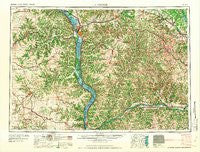
~ La Crosse WI topo map, 1:250000 scale, 1 X 2 Degree, Historical, 1961
La Crosse, Wisconsin, USGS topographic map dated 1961.
Includes geographic coordinates (latitude and longitude). This topographic map is suitable for hiking, camping, and exploring, or framing it as a wall map.
Printed on-demand using high resolution imagery, on heavy weight and acid free paper, or alternatively on a variety of synthetic materials.
Topos available on paper, Waterproof, Poly, or Tyvek. Usually shipping rolled, unless combined with other folded maps in one order.
- Product Number: USGS-5998706
- Free digital map download (high-resolution, GeoPDF): La Crosse, Wisconsin (file size: 12 MB)
- Map Size: please refer to the dimensions of the GeoPDF map above
- Weight (paper map): ca. 55 grams
- Map Type: POD USGS Topographic Map
- Map Series: HTMC
- Map Verison: Historical
- Cell ID: 68862
- Scan ID: 802836
- Woodland Tint: Yes
- Field Check Year: 1958
- Datum: Unstated
- Map Projection: Transverse Mercator
- Map published by United States Geological Survey
- Map Language: English
- Scanner Resolution: 508 dpi
- Map Cell Name: La Crosse
- Grid size: 1 X 2 Degree
- Date on map: 1961
- Map Scale: 1:250000
- Geographical region: Wisconsin, United States
Neighboring Maps:
All neighboring USGS topo maps are available for sale online at a variety of scales.
Spatial coverage:
Topo map La Crosse, Wisconsin, covers the geographical area associated the following places:
- Donehower - Eldergrove - Highland - Brownsville - Hokah - Thoten - Liberty - Muscoda - Angelo - West Salem - Festina - Grand Crossing - Spring Green - Froelich - Red Mound - Newberg Corners - Tomah - Waukon - Excelsior - Wild Rose - Camp Douglas - Barnum - Yankeetown - Kendall - Egan - Corwin (historical) - Germantown - Lansing Valley Mobile City - Brookville - Millville - Green Lea Mobile Home Park - Sparta - Fort Atkinson - Whalan - Dalby - Dakota - Highland Park Estates - Bear Valley - Mill Creek (historical) - Charme - Springwater - Soldiers Grove - Pleasant Valley - Village Terrace - Evergreen Terrace - Peterson - Locust - Hills Mobile Home Park - Ithaca - Ontario - Bluffview Park Mobile Home Park - Pine Knob - Beulah - Twin Bluffs - Balmoral - Mount Zion - Reed - Willington Grove - Pleasant Ridge - Rising Sun - Erickson Trailer Court - Caledonia - Ridgeway - Hanover - Thunderbird Mobile Home Park - Cazenovia - Hill Point - Wilmington - Brice Prairie - Ridgeway - Sixteen - Hustler - Washington Prairie - Sattre - Riceford - West Yards - McGregor - Cold Springs - Hesper - Gillingham - Gays Mills - New Lisbon - Watson - Valdora (historical) - Postville - La Valle - Coon Valley - Leon - Freeburg - Waukon Junction - Petersburg - Jefferson - Port Andrew - Fremont - Johnstown - Clifton - Barre Mills - Reno - Village Creek - Lindina
- Map Area ID: AREA4443-92-90
- Northwest corner Lat/Long code: USGSNW44-92
- Northeast corner Lat/Long code: USGSNE44-90
- Southwest corner Lat/Long code: USGSSW43-92
- Southeast corner Lat/Long code: USGSSE43-90
- Northern map edge Latitude: 44
- Southern map edge Latitude: 43
- Western map edge Longitude: -92
- Eastern map edge Longitude: -90


