
~ Iron Mountain SW WI topo map, 1:24000 scale, 7.5 X 7.5 Minute, Historical, 1962, updated 1990
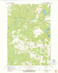
Iron Mountain SW, Wisconsin, USGS topographic map dated 1962.
Includes geographic coordinates (latitude and longitude). This topographic map is suitable for hiking, camping, and exploring, or framing it as a wall map.
Printed on-demand using high resolution imagery, on heavy weight and acid free paper, or alternatively on a variety of synthetic materials.
Topos available on paper, Waterproof, Poly, or Tyvek. Usually shipping rolled, unless combined with other folded maps in one order.
- Product Number: USGS-5998508
- Free digital map download (high-resolution, GeoPDF): Iron Mountain SW, Wisconsin (file size: 10 MB)
- Map Size: please refer to the dimensions of the GeoPDF map above
- Weight (paper map): ca. 55 grams
- Map Type: POD USGS Topographic Map
- Map Series: HTMC
- Map Verison: Historical
- Cell ID: 22074
- Scan ID: 500651
- Imprint Year: 1990
- Woodland Tint: Yes
- Photo Inspection Year: 1980
- Aerial Photo Year: 1958
- Field Check Year: 1962
- Datum: NAD27
- Map Projection: Polyconic
- Map published by United States Geological Survey
- Map Language: English
- Scanner Resolution: 508 dpi
- Map Cell Name: Iron Mountain SW
- Grid size: 7.5 X 7.5 Minute
- Date on map: 1962
- Map Scale: 1:24000
- Geographical region: Wisconsin, United States
Neighboring Maps:
All neighboring USGS topo maps are available for sale online at a variety of scales.
Spatial coverage:
Topo map Iron Mountain SW, Wisconsin, covers the geographical area associated the following places:
- Johnson Creek - South Branch Little Popple River - Spread Eagle Barrens State Natural Area - 0.82 Reservoir - Henry Ford Dam - Hauserman Lake - Frog Lake - Town of Commonwealth - Pine River Power Plant - Lindow G7265 Dam - Roach School (historical) - Hord Lake - Homestead - Homestead Volunteer Fire Department - Spring Lake - Fairview School (historical) - Henry Ford Dam - Lepage Creek - Ellwood Lake - Town of Aurora - Pine Creek - Brown School (historical) - Aurora Free Church - Sand Lake
- Map Area ID: AREA45.87545.75-88.25-88.125
- Northwest corner Lat/Long code: USGSNW45.875-88.25
- Northeast corner Lat/Long code: USGSNE45.875-88.125
- Southwest corner Lat/Long code: USGSSW45.75-88.25
- Southeast corner Lat/Long code: USGSSE45.75-88.125
- Northern map edge Latitude: 45.875
- Southern map edge Latitude: 45.75
- Western map edge Longitude: -88.25
- Eastern map edge Longitude: -88.125


