
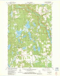
~ Dunn Lake WI topo map, 1:24000 scale, 7.5 X 7.5 Minute, Historical, 1982, updated 1983
Dunn Lake, Wisconsin, USGS topographic map dated 1982.
Includes geographic coordinates (latitude and longitude). This topographic map is suitable for hiking, camping, and exploring, or framing it as a wall map.
Printed on-demand using high resolution imagery, on heavy weight and acid free paper, or alternatively on a variety of synthetic materials.
Topos available on paper, Waterproof, Poly, or Tyvek. Usually shipping rolled, unless combined with other folded maps in one order.
- Product Number: USGS-5997782
- Free digital map download (high-resolution, GeoPDF): Dunn Lake, Wisconsin (file size: 10 MB)
- Map Size: please refer to the dimensions of the GeoPDF map above
- Weight (paper map): ca. 55 grams
- Map Type: POD USGS Topographic Map
- Map Series: HTMC
- Map Verison: Historical
- Cell ID: 13082
- Scan ID: 500354
- Imprint Year: 1983
- Woodland Tint: Yes
- Aerial Photo Year: 1978
- Edit Year: 1982
- Field Check Year: 1980
- Datum: NAD27
- Map Projection: Lambert Conformal Conic
- Map published by United States Geological Survey
- Map Language: English
- Scanner Resolution: 508 dpi
- Map Cell Name: Dunn Lake
- Grid size: 7.5 X 7.5 Minute
- Date on map: 1982
- Map Scale: 1:24000
- Geographical region: Wisconsin, United States
Neighboring Maps:
All neighboring USGS topo maps are available for sale online at a variety of scales.
Spatial coverage:
Topo map Dunn Lake, Wisconsin, covers the geographical area associated the following places:
- Tadpole Corners - Tomahawk Lake - Mud Lake - Boyle Brook - Town of Casey - Conroy Ford 3WR374 Dam - Tower Lake - Casey Lake - Rosewood Cemetery - Jerry Lake - McKinley Lake - Trego Hydro Generating Station - Spring Lake - Boyle Brook Spring - McKenzie Creek - Rocky Ridge Creek - Little Casey Lake - Trego Lake - McKenzie Creek State Public Fishery Area - Island Lake - Trego WP220 Dam - Loon Lake - Schulze-Spooner Airport (historical) - Dunn Lake - Casey Creek Flowage - Leisure Lake - Grass Lake - Goose Lake - Sunfish Lake - Washburn County Youth Camp - Trego Dam - Rigler Lake - Rappy Lake - Bass Lake - Lincoln Lake - Rocky Ridge Lake - Trego Lake 503
- Map Area ID: AREA4645.875-92-91.875
- Northwest corner Lat/Long code: USGSNW46-92
- Northeast corner Lat/Long code: USGSNE46-91.875
- Southwest corner Lat/Long code: USGSSW45.875-92
- Southeast corner Lat/Long code: USGSSE45.875-91.875
- Northern map edge Latitude: 46
- Southern map edge Latitude: 45.875
- Western map edge Longitude: -92
- Eastern map edge Longitude: -91.875


