
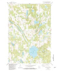
~ Big Round Lake WI topo map, 1:24000 scale, 7.5 X 7.5 Minute, Historical, 1983, updated 1983
Big Round Lake, Wisconsin, USGS topographic map dated 1983.
Includes geographic coordinates (latitude and longitude). This topographic map is suitable for hiking, camping, and exploring, or framing it as a wall map.
Printed on-demand using high resolution imagery, on heavy weight and acid free paper, or alternatively on a variety of synthetic materials.
Topos available on paper, Waterproof, Poly, or Tyvek. Usually shipping rolled, unless combined with other folded maps in one order.
- Product Number: USGS-5997284
- Free digital map download (high-resolution, GeoPDF): Big Round Lake, Wisconsin (file size: 9 MB)
- Map Size: please refer to the dimensions of the GeoPDF map above
- Weight (paper map): ca. 55 grams
- Map Type: POD USGS Topographic Map
- Map Series: HTMC
- Map Verison: Historical
- Cell ID: 3814
- Scan ID: 800284
- Imprint Year: 1983
- Woodland Tint: Yes
- Aerial Photo Year: 1979
- Edit Year: 1983
- Field Check Year: 1979
- Datum: NAD27
- Map Projection: Lambert Conformal Conic
- Map published by United States Geological Survey
- Map Language: English
- Scanner Resolution: 508 dpi
- Map Cell Name: Big Round Lake
- Grid size: 7.5 X 7.5 Minute
- Date on map: 1983
- Map Scale: 1:24000
- Geographical region: Wisconsin, United States
Neighboring Maps:
All neighboring USGS topo maps are available for sale online at a variety of scales.
Spatial coverage:
Topo map Big Round Lake, Wisconsin, covers the geographical area associated the following places:
- Zion Church - Lost Lake - Lamont Lake - Hay Lake - Johnstown Cemetery - Lake Evelyn - Ward Lake - Bass Lake - Depot Lake - Dahl Lake - Lake 18-1 1 - Big Lake - LaFollette School - Devils Marsh - Town of Georgetown - Sucker Creek - Johnson Lake - Little Pine Lake - Cragwood Corporation Number 2 H810 Dam - Saint Croix Reservation - Loon Lake - Footes Lake - Pine Lake - Big Round Lake - Round Lake Chapel - Pickerel Lake - Straight River - Rhinstad Lake - Town of Bone Lake - Long Lake - Sedge Lake - Little Ward Lake - Mackie Lake - Mullins Lake - Vincent Lake - McKenzie Lake - Holst School - Saint Paul Church - Andrus Lake
- Map Area ID: AREA45.62545.5-92.375-92.25
- Northwest corner Lat/Long code: USGSNW45.625-92.375
- Northeast corner Lat/Long code: USGSNE45.625-92.25
- Southwest corner Lat/Long code: USGSSW45.5-92.375
- Southeast corner Lat/Long code: USGSSE45.5-92.25
- Northern map edge Latitude: 45.625
- Southern map edge Latitude: 45.5
- Western map edge Longitude: -92.375
- Eastern map edge Longitude: -92.25


