
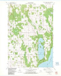
~ Baileys Harbor West WI topo map, 1:24000 scale, 7.5 X 7.5 Minute, Historical, 1982, updated 1983
Baileys Harbor West, Wisconsin, USGS topographic map dated 1982.
Includes geographic coordinates (latitude and longitude). This topographic map is suitable for hiking, camping, and exploring, or framing it as a wall map.
Printed on-demand using high resolution imagery, on heavy weight and acid free paper, or alternatively on a variety of synthetic materials.
Topos available on paper, Waterproof, Poly, or Tyvek. Usually shipping rolled, unless combined with other folded maps in one order.
- Product Number: USGS-5997182
- Free digital map download (high-resolution, GeoPDF): Baileys Harbor West, Wisconsin (file size: 9 MB)
- Map Size: please refer to the dimensions of the GeoPDF map above
- Weight (paper map): ca. 55 grams
- Map Type: POD USGS Topographic Map
- Map Series: HTMC
- Map Verison: Historical
- Cell ID: 2143
- Scan ID: 500087
- Imprint Year: 1983
- Woodland Tint: Yes
- Aerial Photo Year: 1978
- Edit Year: 1982
- Field Check Year: 1980
- Datum: NAD27
- Map Projection: Lambert Conformal Conic
- Map published by United States Geological Survey
- Map Language: English
- Scanner Resolution: 508 dpi
- Map Cell Name: Baileys Harbor West
- Grid size: 7.5 X 7.5 Minute
- Date on map: 1982
- Map Scale: 1:24000
- Geographical region: Wisconsin, United States
Neighboring Maps:
All neighboring USGS topo maps are available for sale online at a variety of scales.
Spatial coverage:
Topo map Baileys Harbor West, Wisconsin, covers the geographical area associated the following places:
- Baileys Harbor Volunteer Fire Department - Bley Farms - Lyle-Harter-Matter County Park - Jarman Quarry - Kangaroo Lake - Haberli Farms - Door County Quarries - Thorp Pond State Natural Area - Meridian County Park - Zion Church - Thorp Pond - Sky Harbor Landing Strip (historical) - Baileys Harbor Census Designated Place - Boynton Chapel - Baileys Harbor Swamp - Lighting Strikes Orchard - Peninsula Center - Gibraltar Fire Department - Saint Paul's Lutheran Church - Peil Creek - Heins Creek - Baileys Harbor Cemetery - Button Marsh - Maxwelton Country Club - Gray Air Dairy Farm - Kangaroo Lake State Natural Area
- Map Area ID: AREA45.12545-87.25-87.125
- Northwest corner Lat/Long code: USGSNW45.125-87.25
- Northeast corner Lat/Long code: USGSNE45.125-87.125
- Southwest corner Lat/Long code: USGSSW45-87.25
- Southeast corner Lat/Long code: USGSSE45-87.125
- Northern map edge Latitude: 45.125
- Southern map edge Latitude: 45
- Western map edge Longitude: -87.25
- Eastern map edge Longitude: -87.125


