
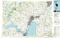
~ Appleton WI topo map, 1:100000 scale, 30 X 60 Minute, Historical, 1984, updated 1985
Appleton, Wisconsin, USGS topographic map dated 1984.
Includes geographic coordinates (latitude and longitude). This topographic map is suitable for hiking, camping, and exploring, or framing it as a wall map.
Printed on-demand using high resolution imagery, on heavy weight and acid free paper, or alternatively on a variety of synthetic materials.
Topos available on paper, Waterproof, Poly, or Tyvek. Usually shipping rolled, unless combined with other folded maps in one order.
- Product Number: USGS-5997092
- Free digital map download (high-resolution, GeoPDF): Appleton, Wisconsin (file size: 16 MB)
- Map Size: please refer to the dimensions of the GeoPDF map above
- Weight (paper map): ca. 55 grams
- Map Type: POD USGS Topographic Map
- Map Series: HTMC
- Map Verison: Historical
- Cell ID: 67059
- Scan ID: 503639
- Imprint Year: 1985
- Woodland Tint: Yes
- Aerial Photo Year: 1982
- Edit Year: 1984
- Datum: NAD27
- Map Projection: Universal Transverse Mercator
- Planimetric: Yes
- Map published by United States Geological Survey
- Map Language: English
- Scanner Resolution: 508 dpi
- Map Cell Name: Appleton
- Grid size: 30 X 60 Minute
- Date on map: 1984
- Map Scale: 1:100000
- Geographical region: Wisconsin, United States
Neighboring Maps:
All neighboring USGS topo maps are available for sale online at a variety of scales.
Spatial coverage:
Topo map Appleton, Wisconsin, covers the geographical area associated the following places:
- Neenah - West De Pere - Fairview Beach - Combined Locks - Kaukauna - Winneconne - Greenleaf - Allenville - Keenville - Eureka - Saint John - Oakwood - Piacenza - Chicago Corners - High Cliff (historical) - Hobart - Lasleys Point - Hatton (historical) - Winchester - Royalton - Eckers Lakeland - Kloten - Weyauwega - Poy Sippi - Harrison (historical) - Nichols Shore Acres - Forest Junction - Shiocton - Brushville - Dundas - Harrison - Rainbow Beach - Dale - Binghamton - Adella Beach - Greenville - Hortonville - Indian Shores - Hayton - Winnebago - Ricker Bay - Saint Catherines Bay - River View Mobile Home Park - Darboy - Brillion - Twelve Corners - Reighmoor - Northport - Sniderville - Brighton Beach - Little Rapids - Auroraville - Fox Crossing - Kimberly - Island Park - Chilton - Holland - Waverly Beach - Oneida - Center Valley - Stockbridge - North Readfield - Harbor Springs - Oshkosh - Melrose Park - Wells - Dorns Faro Springs Beach - Borth - Utowana Beach - Sunset Beach - Highland Shore - Rockaway Beach - Brant - Orihula - Shaw Landing - Rivermoor - Omro - Mackville - Sunrise Bay - Allouez - Hilbert - Potter - Plummer Point - Ashwaubenon - Quinney - Shangri La Point - Menasha - New London - Clarks Point - Askeaton - West Bloomfield - Island Beach - Larsen - Little Wolf (historical) - Red Banks - Appleton - Apple Creek - Highland Beach - Gravesville - Gills Landing
- Map Area ID: AREA44.544-89-88
- Northwest corner Lat/Long code: USGSNW44.5-89
- Northeast corner Lat/Long code: USGSNE44.5-88
- Southwest corner Lat/Long code: USGSSW44-89
- Southeast corner Lat/Long code: USGSSE44-88
- Northern map edge Latitude: 44.5
- Southern map edge Latitude: 44
- Western map edge Longitude: -89
- Eastern map edge Longitude: -88


