
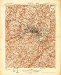
~ Charlottesville And Vicinity VA topo map, 1:31680 scale, 7.5 X 7.5 Minute, Historical, 1935
Charlottesville And Vicinity, Virginia, USGS topographic map dated 1935.
Includes geographic coordinates (latitude and longitude). This topographic map is suitable for hiking, camping, and exploring, or framing it as a wall map.
Printed on-demand using high resolution imagery, on heavy weight and acid free paper, or alternatively on a variety of synthetic materials.
Topos available on paper, Waterproof, Poly, or Tyvek. Usually shipping rolled, unless combined with other folded maps in one order.
- Product Number: USGS-5689690
- Free digital map download (high-resolution, GeoPDF): Charlottesville And Vicinity, Virginia (file size: 20 MB)
- Map Size: please refer to the dimensions of the GeoPDF map above
- Weight (paper map): ca. 55 grams
- Map Type: POD USGS Topographic Map
- Map Series: HTMC
- Map Verison: Historical
- Cell ID: 396027
- Scan ID: 184423
- Survey Year: 1935
- Datum: NAD27
- Map Projection: Polyconic
- Advance: Yes
- Map published by United States Geological Survey
- Map Language: English
- Scanner Resolution: 600 dpi
- Map Cell Name: Charlottesville And Vicinity
- Grid size: 7.5 X 7.5 Minute
- Date on map: 1935
- Map Scale: 1:31680
- Geographical region: Virginia, United States
Neighboring Maps:
All neighboring USGS topo maps are available for sale online at a variety of scales.
Spatial coverage:
Topo map Charlottesville And Vicinity, Virginia, covers the geographical area associated the following places:
- Branchland - Birnam Wood - Ednam Village - Berkmar - Nob Hill - Rio Heights - Townwood - Charlottesville - Simeon - Pen Park - Willoughby - Dunlora Plantation - Woolen Mills - Oak Hill Mobile Home Park - Farmington - Westgate - Huntington Village - Canterbury Hills - Stillfield - Wakefield - Sherwood Manor - Country Green - Belmont - Southwood Estates Mobile Home Park - Pantops - Monacan Town (historical) - Alderman Road Houses - Greenbriar Heights - Mill Creek - Village Square - Berkeley - Flordon - Vinegar Hill - Northerly - Hessian Hills - Buckingham Circle - The Meadows - Commonwealth - Inglecress - Marshall Manor - Willow Heights - Stonehenge - Bellair - Ashcroft - Liberty Hill - Ednam Forest - Montvue - West View Terrace - Glenorchy - Greenfields - Queen Charlotte - Chapel Hills - Rockbrook - Rio - Squire Hill - Stadium Road Residence Area - Barracks - Wildwood - Westfield - Barterbrook - McCormick Road Houses - Raintree - Franklin - Georgetown Green - University Heights - Ednam - Sherwood Farms - Knollwood - Colthurst - Oak Hill - Locust Grove - Camellia Garden - Northfields - Oak Terrace - Riverrun - Key West
- Map Area ID: AREA38.083333337.9583333-78.5583333-78.4333333
- Northwest corner Lat/Long code: USGSNW38.0833333-78.5583333
- Northeast corner Lat/Long code: USGSNE38.0833333-78.4333333
- Southwest corner Lat/Long code: USGSSW37.9583333-78.5583333
- Southeast corner Lat/Long code: USGSSE37.9583333-78.4333333
- Northern map edge Latitude: 38.0833333
- Southern map edge Latitude: 37.9583333
- Western map edge Longitude: -78.5583333
- Eastern map edge Longitude: -78.4333333


