
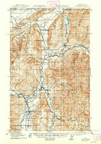
~ Van Zandt WA topo map, 1:62500 scale, 15 X 15 Minute, Historical, 1919, updated 1947
Van Zandt, Washington, USGS topographic map dated 1919.
Includes geographic coordinates (latitude and longitude). This topographic map is suitable for hiking, camping, and exploring, or framing it as a wall map.
Printed on-demand using high resolution imagery, on heavy weight and acid free paper, or alternatively on a variety of synthetic materials.
Topos available on paper, Waterproof, Poly, or Tyvek. Usually shipping rolled, unless combined with other folded maps in one order.
- Product Number: USGS-5687161
- Free digital map download (high-resolution, GeoPDF): Van Zandt, Washington (file size: 11 MB)
- Map Size: please refer to the dimensions of the GeoPDF map above
- Weight (paper map): ca. 55 grams
- Map Type: POD USGS Topographic Map
- Map Series: HTMC
- Map Verison: Historical
- Cell ID: 64039
- Scan ID: 244433
- Imprint Year: 1947
- Survey Year: 1918
- Datum: NAD
- Map Projection: Polyconic
- Map published by United States Army Corps of Engineers
- Map published by United States Department of War
- Keywords: Overedge with No Adjacent Map
- Map Language: English
- Scanner Resolution: 600 dpi
- Map Cell Name: Van Zandt
- Grid size: 15 X 15 Minute
- Date on map: 1919
- Map Scale: 1:62500
- Geographical region: Washington, United States
Neighboring Maps:
All neighboring USGS topo maps are available for sale online at a variety of scales.
Spatial coverage:
Topo map Van Zandt, Washington, covers the geographical area associated the following places:
- Nooksack Salmon Hatchery - Maple Falls - Clipper - Deming - Peaceful Valley - Welcome - Balford - Kulshan - Kendall - Columbia - Limestone Junction - Van Zandt
- Map Area ID: AREA4948.75-122.25-122
- Northwest corner Lat/Long code: USGSNW49-122.25
- Northeast corner Lat/Long code: USGSNE49-122
- Southwest corner Lat/Long code: USGSSW48.75-122.25
- Southeast corner Lat/Long code: USGSSE48.75-122
- Northern map edge Latitude: 49
- Southern map edge Latitude: 48.75
- Western map edge Longitude: -122.25
- Eastern map edge Longitude: -122


