
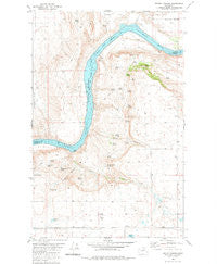
~ Trefry Canyon WA topo map, 1:24000 scale, 7.5 X 7.5 Minute, Historical, 1980, updated 1981
Trefry Canyon, Washington, USGS topographic map dated 1980.
Includes geographic coordinates (latitude and longitude). This topographic map is suitable for hiking, camping, and exploring, or framing it as a wall map.
Printed on-demand using high resolution imagery, on heavy weight and acid free paper, or alternatively on a variety of synthetic materials.
Topos available on paper, Waterproof, Poly, or Tyvek. Usually shipping rolled, unless combined with other folded maps in one order.
- Product Number: USGS-5659950
- Free digital map download (high-resolution, GeoPDF): Trefry Canyon, Washington (file size: 12 MB)
- Map Size: please refer to the dimensions of the GeoPDF map above
- Weight (paper map): ca. 55 grams
- Map Type: POD USGS Topographic Map
- Map Series: HTMC
- Map Verison: Historical
- Cell ID: 45593
- Scan ID: 363029
- Imprint Year: 1981
- Woodland Tint: Yes
- Aerial Photo Year: 1973
- Edit Year: 1980
- Field Check Year: 1975
- Datum: NAD27
- Map Projection: Lambert Conformal Conic
- Map published by United States Geological Survey
- Map Language: English
- Scanner Resolution: 600 dpi
- Map Cell Name: Trefry Canyon
- Grid size: 7.5 X 7.5 Minute
- Date on map: 1980
- Map Scale: 1:24000
- Geographical region: Washington, United States
Neighboring Maps:
All neighboring USGS topo maps are available for sale online at a variety of scales.
Spatial coverage:
Topo map Trefry Canyon, Washington, covers the geographical area associated the following places:
- Twin Rocks - Benson Spring - Granite Rapids - Phil Canyon - Charlies Springs - Saddle Horse Flat - Gordon Sellers Spring - Willock Springs - Del Rio - Mutter Spring - Trefry Springs - Grove Spring - Castle Rock - Zeemal Spring - Victor Spring - Tombstone Rocks - Browns Well - Alec Canyon - Del Rio School - Fox Spring - Buck Spring - Okanogan County Fire District 8 Timm Unit - Sellers Spring - Trefry Canyon - Sharick Spring - Tag Ear Lake - Del Rio - Jackass Butte - Walter Sellers Springs - Allen Bar - Pike Spring - Island Shoal - Henderson Canyon - School Section Spring - Long Ridge - Brazel Spring - Okanogan County Fire District 8 Wells Unit - Del Rio Grange Hall - Devendahl Spring - Parson Rapids - Pencil Spring - Weber Spring - Negro Spring
- Map Area ID: AREA48.12548-119.375-119.25
- Northwest corner Lat/Long code: USGSNW48.125-119.375
- Northeast corner Lat/Long code: USGSNE48.125-119.25
- Southwest corner Lat/Long code: USGSSW48-119.375
- Southeast corner Lat/Long code: USGSSE48-119.25
- Northern map edge Latitude: 48.125
- Southern map edge Latitude: 48
- Western map edge Longitude: -119.375
- Eastern map edge Longitude: -119.25


