
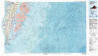
~ Cheriton VA topo map, 1:100000 scale, 30 X 60 Minute, Historical, 1981, updated 1981
Cheriton, Virginia, USGS topographic map dated 1981.
Includes geographic coordinates (latitude and longitude). This topographic map is suitable for hiking, camping, and exploring, or framing it as a wall map.
Printed on-demand using high resolution imagery, on heavy weight and acid free paper, or alternatively on a variety of synthetic materials.
Topos available on paper, Waterproof, Poly, or Tyvek. Usually shipping rolled, unless combined with other folded maps in one order.
- Product Number: USGS-5659744
- Free digital map download (high-resolution, GeoPDF): Cheriton, Virginia (file size: 44 MB)
- Map Size: please refer to the dimensions of the GeoPDF map above
- Weight (paper map): ca. 55 grams
- Map Type: POD USGS Topographic Map
- Map Series: HTMC
- Map Verison: Historical
- Cell ID: 67280
- Scan ID: 188776
- Imprint Year: 1981
- Woodland Tint: Yes
- Aerial Photo Year: 1977
- Edit Year: 1981
- Datum: NAD27
- Map Projection: Universal Transverse Mercator
- Map published by United States Geological Survey
- Keywords: Overedge
- Map Language: English
- Scanner Resolution: 600 dpi
- Map Cell Name: Cheriton
- Grid size: 30 X 60 Minute
- Date on map: 1981
- Map Scale: 1:100000
- Geographical region: Virginia, United States
Neighboring Maps:
All neighboring USGS topo maps are available for sale online at a variety of scales.
Spatial coverage:
Topo map Cheriton, Virginia, covers the geographical area associated the following places:
- Dalbys - Cheriton - Shadyside - Little Salisbury - Sheps End - Martins Siding - Nassawadox Estates - Hare Valley Estates - Townsend - Birdsnest - Kiptopeke - Woodstock - James Crossroads - Magotha - Eastville - Johnsontown - Oyster - Kendall Grove - Machipongo - Nassawadox - Peaceful Beach Estates - Church Creek Point - Capeville - Red Bank - Hungars Point - Cardinal Estates - Westerhouse Woods - Middletown - Deerfield Estates - Collins Estates - Nottingham - Culls - Weirwood - Bayford - Eastville Station - Vaucluse Shores - Marionville - Kendall Grove Estates - Cheapside - Hare Valley - Franktown - Bridgetown - Bulls Landing - Bayview - Bayleys Neck Farm - Fairview - Stumptown - Chesapeake - Seaview - Hideaway Cove - Cedar Grove - Silver Beach - Pat Town - Treherneville - Cape Junction - Reedtown - Brownsville (historical) - Broadwater - The Meadows - Harbour Point - Little Johnsontown - Solitude Trails - Smith Beach - Red Bank - Beverly - Simpkins
- Map Area ID: AREA37.537-76-75
- Northwest corner Lat/Long code: USGSNW37.5-76
- Northeast corner Lat/Long code: USGSNE37.5-75
- Southwest corner Lat/Long code: USGSSW37-76
- Southeast corner Lat/Long code: USGSSE37-75
- Northern map edge Latitude: 37.5
- Southern map edge Latitude: 37
- Western map edge Longitude: -76
- Eastern map edge Longitude: -75


