
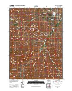
~ Wolf Point WY topo map, 1:24000 scale, 7.5 X 7.5 Minute, Historical, 2012
Wolf Point, Wyoming, USGS topographic map dated 2012.
Includes geographic coordinates (latitude and longitude). This topographic map is suitable for hiking, camping, and exploring, or framing it as a wall map.
Printed on-demand using high resolution imagery, on heavy weight and acid free paper, or alternatively on a variety of synthetic materials.
Topos available on paper, Waterproof, Poly, or Tyvek. Usually shipping rolled, unless combined with other folded maps in one order.
- Product Number: USGS-5649417
- Free digital map download (high-resolution, GeoPDF): Wolf Point, Wyoming (file size: 20 MB)
- Map Size: please refer to the dimensions of the GeoPDF map above
- Weight (paper map): ca. 55 grams
- Map Type: POD USGS Topographic Map
- Map Series: US Topo
- Map Verison: Historical
- Cell ID: 49673
- Datum: North American Datum of 1983
- Map Projection: Transverse Mercator
- Map Cell Name: Wolf Point
- Grid size: 7.5 X 7.5 Minute
- Date on map: 2012
- Map Scale: 1:24000
- Geographical region: Wyoming, United States
Neighboring Maps:
All neighboring USGS topo maps are available for sale online at a variety of scales.
Spatial coverage:
Topo map Wolf Point, Wyoming, covers the geographical area associated the following places:
- Weed Draw - Weiser Draw - Dry Lake - Pan Group Mine - Barrett Creek Mine - Foster Draw - Cherry Creek - Young Basin - Tige Alder Draw - Cherry Creek Mine - Wilkinson Ranch - Whitehead Ranch - Macfie Ranch - Harvey Basin - Upper Willow Creek School - Red Canyon Rim - Canyon Creek - Little Popo Agie Cemetery - Gabel Draw - Madison Creek School - Wilkinson Sheep Sheds - Little Popo Agie Canyon - Madison Creek - Wolf Point - Pat Number Two Mine - Young Mountain - Blue Hill Lateral - Randolph Gulch - Red Canyon - Browns Canyon - Mat Weed Canyon Mine - Cherry Creek Canyon - Barrett Creek - Lower Willow Creek School - Halls Gulch - Beason Creek - Orchard Draw - Devils Creek - Dry Lake Area Mine - Macfie Ranch Mine - Little Popo Agie River Mine - Red Canyon Creek - Red Canyon Creek - Deep Creek
- Map Area ID: AREA42.7542.625-108.75-108.625
- Northwest corner Lat/Long code: USGSNW42.75-108.75
- Northeast corner Lat/Long code: USGSNE42.75-108.625
- Southwest corner Lat/Long code: USGSSW42.625-108.75
- Southeast corner Lat/Long code: USGSSE42.625-108.625
- Northern map edge Latitude: 42.75
- Southern map edge Latitude: 42.625
- Western map edge Longitude: -108.75
- Eastern map edge Longitude: -108.625


