
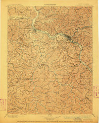
~ Charleston WV topo map, 1:125000 scale, 30 X 30 Minute, Historical, 1899, updated 1910
Charleston, West Virginia, USGS topographic map dated 1899.
Includes geographic coordinates (latitude and longitude). This topographic map is suitable for hiking, camping, and exploring, or framing it as a wall map.
Printed on-demand using high resolution imagery, on heavy weight and acid free paper, or alternatively on a variety of synthetic materials.
Topos available on paper, Waterproof, Poly, or Tyvek. Usually shipping rolled, unless combined with other folded maps in one order.
- Product Number: USGS-5638691
- Free digital map download (high-resolution, GeoPDF): Charleston, West Virginia (file size: 12 MB)
- Map Size: please refer to the dimensions of the GeoPDF map above
- Weight (paper map): ca. 55 grams
- Map Type: POD USGS Topographic Map
- Map Series: HTMC
- Map Verison: Historical
- Cell ID: 395872
- Scan ID: 253960
- Imprint Year: 1910
- Survey Year: 1897
- Datum: Unstated
- Map Projection: Unstated
- Map published by United States Geological Survey
- Map Language: English
- Scanner Resolution: 600 dpi
- Map Cell Name: Charleston
- Grid size: 30 X 30 Minute
- Date on map: 1899
- Map Scale: 1:125000
- Geographical region: West Virginia, United States
Neighboring Maps:
All neighboring USGS topo maps are available for sale online at a variety of scales.
Spatial coverage:
Topo map Charleston, West Virginia, covers the geographical area associated the following places:
- Joes Creek - Windsong Acres - Jefferson - Sun Valley - Estep - Nellis - Williams Mountain - Loudendale - Beech Park Acres - Mount Vernon Meadows - Uneeda - Milliken - Riverside Mobile Home Park - Kirbyton - Charleston - Sylvester - Aarons - Rolling Meadows - Woods and Irons - Twin Rivers Mobile Home Park - South Park - Cabot - Lanham - Sattes - Priestley - Grippe - Parkway Terrace - Lone Oak Park - Danville - Nelson - Pocatalico - Edgewood Acres - Copenhaver (historical) - Airport Village - Teays Valley Estates - Sweet Acres - Seth - Haddleton - Big Chimney - Peytona - East Nitro - Green Valley - Lincoln (historical) - Woodcliffe Chase - Candlewyck Place - Irene - North Charleston - Belle - Rock Lake Village - Diamond - Knollwood - Scott Village - Teays - Forks of Coal - Breece - Vandalia - Scary - Country Villas - Blackhawk - Teays Valley Meadows - McCorkle - Fort Hill - Colonial Gardens - East (historical) - South Charleston - Spring Hill - Forest Hills - Coopertown - Elk Forest - Ferrell - Cameo - Garretts Bend - Ivydale - Morgans Landing - Edgewood - South Hills - Lower Falls - Andrew - Hollyhurst - Loudon Heights - Barlow (historical) - Mound (historical) - Tango - Calvert (historical) - Villa (historical) - Dungriff - Saint Albans - Malden - Mount Hope - The Ridge Estates - Englewood Estates - Wilson - Belle Acres - Brush Creek - Turtle Creek - Sterling (historical) - Maxine - Oakwood Estates - Comfort - River Bend
- Map Area ID: AREA38.538-82-81.5
- Northwest corner Lat/Long code: USGSNW38.5-82
- Northeast corner Lat/Long code: USGSNE38.5-81.5
- Southwest corner Lat/Long code: USGSSW38-82
- Southeast corner Lat/Long code: USGSSE38-81.5
- Northern map edge Latitude: 38.5
- Southern map edge Latitude: 38
- Western map edge Longitude: -82
- Eastern map edge Longitude: -81.5


