
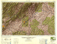
~ Roanoke VA topo map, 1:250000 scale, 1 X 2 Degree, Historical, 1947, updated 1948
Roanoke, Virginia, USGS topographic map dated 1947.
Includes geographic coordinates (latitude and longitude). This topographic map is suitable for hiking, camping, and exploring, or framing it as a wall map.
Printed on-demand using high resolution imagery, on heavy weight and acid free paper, or alternatively on a variety of synthetic materials.
Topos available on paper, Waterproof, Poly, or Tyvek. Usually shipping rolled, unless combined with other folded maps in one order.
- Product Number: USGS-5638433
- Free digital map download (high-resolution, GeoPDF): Roanoke, Virginia (file size: 15 MB)
- Map Size: please refer to the dimensions of the GeoPDF map above
- Weight (paper map): ca. 55 grams
- Map Type: POD USGS Topographic Map
- Map Series: HTMC
- Map Verison: Historical
- Cell ID: 74983
- Scan ID: 707551
- Imprint Year: 1948
- Woodland Tint: Yes
- Visual Version Number: 2
- Aerial Photo Year: 1944
- Datum: NAD27
- Map Projection: Transverse Mercator
- Shaded Relief map: Yes
- Map published by United States Army Corps of Engineers
- Map published by United States Army
- Map Language: English
- Scanner Resolution: 508 dpi
- Map Cell Name: Roanoke
- Grid size: 1 X 2 Degree
- Date on map: 1947
- Map Scale: 1:250000
- Geographical region: Virginia, United States
Neighboring Maps:
All neighboring USGS topo maps are available for sale online at a variety of scales.
Spatial coverage:
Topo map Roanoke, Virginia, covers the geographical area associated the following places:
- Westbrook - Oakdale - Brooklawn - Upson Addition - Gilmore Mills - Hollins Court - South River - Mayflower Hills - Jamestown (historical) - New Glasgow - Bocock - Shannon Hills Estates - Heards - Shadeland - Doral Acres - Kingswood - Old Mill - Glenmore - Lakewood - Prospect - Beechwood Gardens - Balcony Falls - Hendersons Store - Murat - Janette Land - Cohasset - Wyatt (historical) - Crafton - Rodophil - Paynes Mill - Waterfall Lake - College Park - Smiths Paradise - Davis - Windsor Hills - Sleepy Hollow - Trenton Mills - Oak Forest - Hipes - Perkins Park - Summerdean - Howell - Countryside Estates - Iron Gate - North Hills - Ballsville - Camm - Comptons Bridge (historical) - Madison Heights - Lake Monticello - Belmont Acres - Royal Oaks Estates - Fleming Oaks - Taggart - City Gomingo - Great Oaks - Green Meadows - Naruna - Bryant Heights - Thornecrest - Penlan - Chatham Hill - River Edge - Goode - Evergreen - McCullough - Raines Tavern - Jetersville - Fears Corner - Blue Ridge - Oronoco - Shady Lane - Walkers Ford - Allwood - Pelican Point - Mentow - Grandin Court - Cunningham - Axtell - Fairfield - Helm - Meadewood - Bellview Terrace - Holly Hills South - Valley View - Troutville - Westwood - Straightstone - Bruceville - Crewe - Locust Gardens Mobile Home Park - Robertsons (historical) - Forest Park - Sleepy Hollow - Millboro - Cobleshaw - Heritage Acres - Pamplin - Northwood Heights - Hardy Ford
- Map Area ID: AREA3837-80-78
- Northwest corner Lat/Long code: USGSNW38-80
- Northeast corner Lat/Long code: USGSNE38-78
- Southwest corner Lat/Long code: USGSSW37-80
- Southeast corner Lat/Long code: USGSSE37-78
- Northern map edge Latitude: 38
- Southern map edge Latitude: 37
- Western map edge Longitude: -80
- Eastern map edge Longitude: -78


