
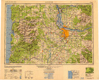
~ Vancouver WA topo map, 1:250000 scale, 1 X 2 Degree, Historical, 1950, updated 1950
Vancouver, Washington, USGS topographic map dated 1950.
Includes geographic coordinates (latitude and longitude). This topographic map is suitable for hiking, camping, and exploring, or framing it as a wall map.
Printed on-demand using high resolution imagery, on heavy weight and acid free paper, or alternatively on a variety of synthetic materials.
Topos available on paper, Waterproof, Poly, or Tyvek. Usually shipping rolled, unless combined with other folded maps in one order.
- Product Number: USGS-5631359
- Free digital map download (high-resolution, GeoPDF): Vancouver, Washington (file size: 17 MB)
- Map Size: please refer to the dimensions of the GeoPDF map above
- Weight (paper map): ca. 55 grams
- Map Type: POD USGS Topographic Map
- Map Series: HTMC
- Map Verison: Historical
- Cell ID: 75026
- Scan ID: 707655
- Imprint Year: 1950
- Woodland Tint: Yes
- Aerial Photo Year: 1945
- Edit Year: 1948
- Datum: NAD27
- Map Projection: Transverse Mercator
- Shaded Relief map: Yes
- Map published by United States Geological Survey
- Map published by United States Army Corps of Engineers
- Map published by United States Army
- Map Language: English
- Scanner Resolution: 508 dpi
- Map Cell Name: Vancouver
- Grid size: 1 X 2 Degree
- Date on map: 1950
- Map Scale: 1:250000
- Geographical region: Washington, United States
Neighboring Maps:
All neighboring USGS topo maps are available for sale online at a variety of scales.
Spatial coverage:
Topo map Vancouver, Washington, covers the geographical area associated the following places:
- Parkrose - Watts - Glen Echo - Elmonica - Colton - Noble (historical) - Sheridan - Molalla - Dodson - Ellsworth - Brighton - Good Hope - Wheeler Heights - Proebstel - New Era - Alder Creek - Felida - Denver (historical) - West Portland - Westimber (historical) - Redland - Dundee - Neahkahnie Beach - Lukarilla - Saint Johns - Hazelwood - Sifton - Lone Elder - Laurelwood - Needy - Yale - Paradise Park - Elwood - Marquam Hill - Bay City - Maplewood - Witch Hazel - Oretown - Hayes - Cedar Hills - Pine Grove - Dole - Interlachen - Belle Passi (historical) - Jewell - Downs - Mountaindale - Batterson - Fern Prairie - Bradley Corner - Scotton Corner - Mishawaka - Garden Home - Hall - Arleta - Corey Hill - Union - Creswell Heights - Rex - Manzanita - Bryant - Johnson Crossing - Park Place - Bethel Heights - Pittsburg - Hazel Green - Carlton - Lunnville - Blaine - Ballston - Saint Cloud - Bayside Gardens - West Union - Farmington - Fishers Corner - Deep Creek (historical) - Champoeg - Durham - Lake Grove (historical) - Cherryville - Folkenberg - Sunnycrest - Saint John - Alameda - Zena - Rosemont - Christie (historical) - Chapman Landing - Burton Homes - Saint Joseph - Waverly Heights - Vernonia - North Howell - Yoder - Midway - Officers Row - O'Neil Corners - Fairdale (historical) - Woodstock - North Highland
- Map Area ID: AREA4645-124-122
- Northwest corner Lat/Long code: USGSNW46-124
- Northeast corner Lat/Long code: USGSNE46-122
- Southwest corner Lat/Long code: USGSSW45-124
- Southeast corner Lat/Long code: USGSSE45-122
- Northern map edge Latitude: 46
- Southern map edge Latitude: 45
- Western map edge Longitude: -124
- Eastern map edge Longitude: -122


