
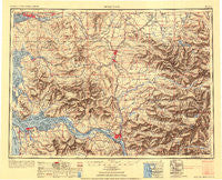
~ Hoquiam WA topo map, 1:250000 scale, 1 X 2 Degree, Historical, 1953
Hoquiam, Washington, USGS topographic map dated 1953.
Includes geographic coordinates (latitude and longitude). This topographic map is suitable for hiking, camping, and exploring, or framing it as a wall map.
Printed on-demand using high resolution imagery, on heavy weight and acid free paper, or alternatively on a variety of synthetic materials.
Topos available on paper, Waterproof, Poly, or Tyvek. Usually shipping rolled, unless combined with other folded maps in one order.
- Product Number: USGS-5631357
- Free digital map download (high-resolution, GeoPDF): Hoquiam, Washington (file size: 16 MB)
- Map Size: please refer to the dimensions of the GeoPDF map above
- Weight (paper map): ca. 55 grams
- Map Type: POD USGS Topographic Map
- Map Series: HTMC
- Map Verison: Historical
- Cell ID: 75031
- Scan ID: 707402
- Aerial Photo Year: 1945
- Datum: NAD27
- Map Projection: Transverse Mercator
- Shaded Relief map: Yes
- Map published by United States Army Corps of Engineers
- Map published by United States Army
- Map Language: English
- Scanner Resolution: 508 dpi
- Map Cell Name: Hoquiam
- Grid size: 1 X 2 Degree
- Date on map: 1953
- Map Scale: 1:250000
- Geographical region: Washington, United States
Neighboring Maps:
All neighboring USGS topo maps are available for sale online at a variety of scales.
Spatial coverage:
Topo map Hoquiam, Washington, covers the geographical area associated the following places:
- Saint Urban - Prescott - Artic - Ostrander - Alder Grove - Lankner - Kopiah - Kellys Korner - Columbia Heights - South Aberdeen - Mima - Curtis - Upper Salmon Junction - Burnside (historical) - Longview Junction - Linkshire Market Mobile Home Park - Country Green Estates Mobile Home Park - South Union - Belmore - Ethel - Offutt Lake - Grays River - Woodson - Rosburg - Surf Pines - Holcomb - Hudson (historical) - Oklahoma Hill - Willapa - Westport - Forest - Alder - Balch - Lindbergh - Rose Valley - Aberdeen - Menlo - Eastgate Mobile Home Park - Newaukum - Bucoda - Electron - Frankfort - Rosewood Manor Mobile Home Park - Alston - Kerry - Hidden Valley Mobile Home Park - Burt - Monticello (historical) - Tono - Plumb - Miles Crossing - Wilson - Cougar - Riffe (historical) - Hoquiam - Pilgrim Heights - Markham - La Grande - Kosmos (historical) - Bay Center - Elbe - McGowan - Cathlamet - Longview Heights - Vail - Coal Creek - Oakville - Brownsmead - Olney - Surprise Valley - Harrington Place - Greenwood - Ajlune - Carrolls - Nulls Crossing - Brookfield - Sutico - Seahaven (historical) - Chadwell (historical) - Morton - Svensens Landing - Saginaw - Seaport (historical) - Jims Corner - South Elma - Nesika - Ceres - Harmony Falls Landing (historical) - Eatonville Junction - Clatskanie Heights - Dahlia - Aberdeen Junction - Castle Rock - Maytown - Naselle - Blakeslee Junction - Nallpee - Bedford - Mossyrock - Sandy Bend
- Map Area ID: AREA4746-124-122
- Northwest corner Lat/Long code: USGSNW47-124
- Northeast corner Lat/Long code: USGSNE47-122
- Southwest corner Lat/Long code: USGSSW46-124
- Southeast corner Lat/Long code: USGSSE46-122
- Northern map edge Latitude: 47
- Southern map edge Latitude: 46
- Western map edge Longitude: -124
- Eastern map edge Longitude: -122


