
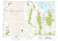
~ Tooele UT topo map, 1:250000 scale, 1 X 2 Degree, Historical, 1953, updated 1968
Tooele, Utah, USGS topographic map dated 1953.
Includes geographic coordinates (latitude and longitude). This topographic map is suitable for hiking, camping, and exploring, or framing it as a wall map.
Printed on-demand using high resolution imagery, on heavy weight and acid free paper, or alternatively on a variety of synthetic materials.
Topos available on paper, Waterproof, Poly, or Tyvek. Usually shipping rolled, unless combined with other folded maps in one order.
- Product Number: USGS-5631341
- Free digital map download (high-resolution, GeoPDF): Tooele, Utah (file size: 19 MB)
- Map Size: please refer to the dimensions of the GeoPDF map above
- Weight (paper map): ca. 55 grams
- Map Type: POD USGS Topographic Map
- Map Series: HTMC
- Map Verison: Historical
- Cell ID: 75005
- Scan ID: 321788
- Imprint Year: 1968
- Woodland Tint: Yes
- Edit Year: 1962
- Field Check Year: 1953
- Datum: Unstated
- Map Projection: Transverse Mercator
- Map published by United States Geological Survey
- Map published by United States Army Corps of Engineers
- Map published by United States Army
- Map Language: English
- Scanner Resolution: 600 dpi
- Map Cell Name: Tooele
- Grid size: 1 X 2 Degree
- Date on map: 1953
- Map Scale: 1:250000
- Geographical region: Utah, United States
Neighboring Maps:
All neighboring USGS topo maps are available for sale online at a variety of scales.
Spatial coverage:
Topo map Tooele, Utah, covers the geographical area associated the following places:
- Sundown - Hunter - Pleasant Green Acres Subdivision - Harmony Lane - Bailey - Garden Lot Addition - Crestview - Westridge - Copperton - Copper City - Arlington Park - Topliff - Sunset Downs - Silver Meadows - Higate Hamlet - Western Sun - Terra - Chaparral West - Lago - Aragonite - Copper View Estates - Gold Hill - Brookfield - Mercur (historical) - Brook Hollow - Lofgreen - Falconcrest - Canyon West - Rushton Acres - Sue Ann - Pehrson - Brook Hollow Estates - Kevinwood Estates - Green Meadows Estates - Copper Hill Heights Nine and Ten - Athens - Oquirrh Hills Subdivision - Magna Manors - Chateau Village - Brooklawn Estates - Robbe - Brady Place - Foothills - Oquirlane - Brookhaven - Hunter Hills - Merry Lane - Copper Cove Condominium - Kimberly Crest - Chambers Townsite - West Hills - Timpie - Flangas - Pleasant Valley - Cockerills Addition - Century Condominium - Polaris Gardens - Hi Country Estates - Marshall - Hunter Village Condominium - Magna - Iosepa (historical) - Hoffman Heights - Lakato Estates - Wood Haven - Patterson Addition Magna - Copperview Village Condominium - Thompson Acres - Center - Pleasant Green Acres Subdivision 3-9 - East Magna - Williamsburg Estates - Burmester - Wane/Match - Woodview Heights - Dolomite - Copper Cove - Deerfield - Blair - Vernon - Lark (historical) - Country Creek Estates Five - Flux - Lake Ridge - Sundown - Mac Sweeney Estates - Sunset Hills - Sunny Side - Southfork - Herriman - Eggli Acres - Dial Heights - Faust - Colony West Subdivision - Numbers 13, 14 and 15 - Delle - Magna Mill - Valley View Park - Bello Park - Martin Village - Day Park
- Map Area ID: AREA4140-114-112
- Northwest corner Lat/Long code: USGSNW41-114
- Northeast corner Lat/Long code: USGSNE41-112
- Southwest corner Lat/Long code: USGSSW40-114
- Southeast corner Lat/Long code: USGSSE40-112
- Northern map edge Latitude: 41
- Southern map edge Latitude: 40
- Western map edge Longitude: -114
- Eastern map edge Longitude: -112


