
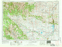
~ Thermopolis WY topo map, 1:250000 scale, 1 X 2 Degree, Historical, 1955, updated 1969
Thermopolis, Wyoming, USGS topographic map dated 1955.
Includes geographic coordinates (latitude and longitude). This topographic map is suitable for hiking, camping, and exploring, or framing it as a wall map.
Printed on-demand using high resolution imagery, on heavy weight and acid free paper, or alternatively on a variety of synthetic materials.
Topos available on paper, Waterproof, Poly, or Tyvek. Usually shipping rolled, unless combined with other folded maps in one order.
- Product Number: USGS-5618066
- Free digital map download (high-resolution, GeoPDF): Thermopolis, Wyoming (file size: 21 MB)
- Map Size: please refer to the dimensions of the GeoPDF map above
- Weight (paper map): ca. 55 grams
- Map Type: POD USGS Topographic Map
- Map Series: HTMC
- Map Verison: Historical
- Cell ID: 69052
- Scan ID: 342614
- Imprint Year: 1969
- Woodland Tint: Yes
- Edit Year: 1962
- Field Check Year: 1955
- Datum: Unstated
- Map Projection: Transverse Mercator
- Map published by United States Geological Survey
- Map published by United States Army Corps of Engineers
- Map published by United States Army
- Map Language: English
- Scanner Resolution: 600 dpi
- Map Cell Name: Thermopolis
- Grid size: 1 X 2 Degree
- Date on map: 1955
- Map Scale: 1:250000
- Geographical region: Wyoming, United States
Neighboring Maps:
All neighboring USGS topo maps are available for sale online at a variety of scales.
Spatial coverage:
Topo map Thermopolis, Wyoming, covers the geographical area associated the following places:
- Thermopolis - Fort Washakie - East Thermopolis - Bain Place - Lucerne - Shoshoni - Grass Creek - Kirby - Hamilton Dome - South Flat - Red Lane - Embar - Winchester - DuNoir - Riverton - Bonneville - Owl Creek - Midvale - Johnstown - Kirwin - Colter - Nickelson Place - Collins Place - Minnesela - Morton - Dubois - Willow Creek - Burris - Boysen - Ethete - Kinnear - Pavillion - Crowheart
- Map Area ID: AREA4443-110-108
- Northwest corner Lat/Long code: USGSNW44-110
- Northeast corner Lat/Long code: USGSNE44-108
- Southwest corner Lat/Long code: USGSSW43-110
- Southeast corner Lat/Long code: USGSSE43-108
- Northern map edge Latitude: 44
- Southern map edge Latitude: 43
- Western map edge Longitude: -110
- Eastern map edge Longitude: -108


