
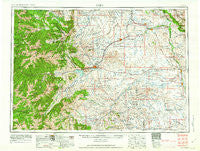
~ Cody WY topo map, 1:250000 scale, 1 X 2 Degree, Historical, 1962, updated 1962
Cody, Wyoming, USGS topographic map dated 1962.
Includes geographic coordinates (latitude and longitude). This topographic map is suitable for hiking, camping, and exploring, or framing it as a wall map.
Printed on-demand using high resolution imagery, on heavy weight and acid free paper, or alternatively on a variety of synthetic materials.
Topos available on paper, Waterproof, Poly, or Tyvek. Usually shipping rolled, unless combined with other folded maps in one order.
- Product Number: USGS-5617992
- Free digital map download (high-resolution, GeoPDF): Cody, Wyoming (file size: 22 MB)
- Map Size: please refer to the dimensions of the GeoPDF map above
- Weight (paper map): ca. 55 grams
- Map Type: POD USGS Topographic Map
- Map Series: HTMC
- Map Verison: Historical
- Cell ID: 68723
- Scan ID: 342577
- Imprint Year: 1962
- Woodland Tint: Yes
- Aerial Photo Year: 1955
- Edit Year: 1962
- Datum: Unstated
- Map Projection: Transverse Mercator
- Map published by United States Army Corps of Engineers
- Map published by United States Army
- Map Language: English
- Scanner Resolution: 600 dpi
- Map Cell Name: Cody
- Grid size: 1 X 2 Degree
- Date on map: 1962
- Map Scale: 1:250000
- Geographical region: Wyoming, United States
Neighboring Maps:
All neighboring USGS topo maps are available for sale online at a variety of scales.
Spatial coverage:
Topo map Cody, Wyoming, covers the geographical area associated the following places:
- Lone Tree Crossing - Meeteetse - Emblem - Badger Basin - Elk Basin - Dumbell - Greybull - Garland - Ralston - Fenton - Cowley - Otto - Byron - Lovell - Clark - Powell - Basin - Cody - Sunshine - Hawkeye - Sales Place - Frannie - Willwood - Wapiti - Hewitt Place - Vocation - Kamms Corner - Dry Creek - Deaver - Kane - Burlington - Pahaska Tepee
- Map Area ID: AREA4544-110-108
- Northwest corner Lat/Long code: USGSNW45-110
- Northeast corner Lat/Long code: USGSNE45-108
- Southwest corner Lat/Long code: USGSSW44-110
- Southeast corner Lat/Long code: USGSSE44-108
- Northern map edge Latitude: 45
- Southern map edge Latitude: 44
- Western map edge Longitude: -110
- Eastern map edge Longitude: -108


