
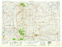
~ Cheyenne WY topo map, 1:250000 scale, 1 X 2 Degree, Historical, 1958, updated 1958
Cheyenne, Wyoming, USGS topographic map dated 1958.
Includes geographic coordinates (latitude and longitude). This topographic map is suitable for hiking, camping, and exploring, or framing it as a wall map.
Printed on-demand using high resolution imagery, on heavy weight and acid free paper, or alternatively on a variety of synthetic materials.
Topos available on paper, Waterproof, Poly, or Tyvek. Usually shipping rolled, unless combined with other folded maps in one order.
- Product Number: USGS-5617986
- Free digital map download (high-resolution, GeoPDF): Cheyenne, Wyoming (file size: 16 MB)
- Map Size: please refer to the dimensions of the GeoPDF map above
- Weight (paper map): ca. 55 grams
- Map Type: POD USGS Topographic Map
- Map Series: HTMC
- Map Verison: Historical
- Cell ID: 75009
- Scan ID: 342574
- Imprint Year: 1958
- Woodland Tint: Yes
- Visual Version Number: 1
- Field Check Year: 1954
- Datum: Unstated
- Map Projection: Transverse Mercator
- Map published by United States Army Corps of Engineers
- Map published by United States Army
- Map Language: English
- Scanner Resolution: 600 dpi
- Map Cell Name: Cheyenne
- Grid size: 1 X 2 Degree
- Date on map: 1958
- Map Scale: 1:250000
- Geographical region: Wyoming, United States
Neighboring Maps:
All neighboring USGS topo maps are available for sale online at a variety of scales.
Spatial coverage:
Topo map Cheyenne, Wyoming, covers the geographical area associated the following places:
- Egbert - Pine Bluffs - Murke - Islay - Harmony - Diamond - La Grange - Gleason - Horse Creek - Henry - Granite - Janise - Orchard Valley - Veteran - Tie Siding - Red Buttes - Tracy - Cheyenne - Natwick - Bosler Junction - Millbrook - Fonda - Hermosa - Harper - Ferguson Corner - Hecla - Mers Hill - Brinton - Laramie - Burns - Rock River - Yoder - Otto - Rock Creek (historical) - Trelona (historical) - Hawk Springs - Ranchettes - Wyoming - Wycross - Lambert - Altvan - Chugwater - Farthing - Hirsig - Speer - Tremain - Lookout - Hillsdale - Bordeaux - Arcola - Wilcox - Sears - Buford - Lyman - Cooper Lake - Huntley - Athol - Durham - Dale Creek - The Buttes - Bosler - Hatton - Albin - Silver Tip - Howell - South Greeley - Slater - Sherman - Carpenter - Meriden - West Laramie
- Map Area ID: AREA4241-106-104
- Northwest corner Lat/Long code: USGSNW42-106
- Northeast corner Lat/Long code: USGSNE42-104
- Southwest corner Lat/Long code: USGSSW41-106
- Southeast corner Lat/Long code: USGSSE41-104
- Northern map edge Latitude: 42
- Southern map edge Latitude: 41
- Western map edge Longitude: -106
- Eastern map edge Longitude: -104


