
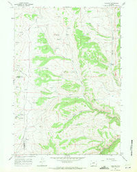
~ Tabletop WY topo map, 1:24000 scale, 7.5 X 7.5 Minute, Historical, 1967, updated 1971
Tabletop, Wyoming, USGS topographic map dated 1967.
Includes geographic coordinates (latitude and longitude). This topographic map is suitable for hiking, camping, and exploring, or framing it as a wall map.
Printed on-demand using high resolution imagery, on heavy weight and acid free paper, or alternatively on a variety of synthetic materials.
Topos available on paper, Waterproof, Poly, or Tyvek. Usually shipping rolled, unless combined with other folded maps in one order.
- Product Number: USGS-5616240
- Free digital map download (high-resolution, GeoPDF): Tabletop, Wyoming (file size: 10 MB)
- Map Size: please refer to the dimensions of the GeoPDF map above
- Weight (paper map): ca. 55 grams
- Map Type: POD USGS Topographic Map
- Map Series: HTMC
- Map Verison: Historical
- Cell ID: 44163
- Scan ID: 341618
- Imprint Year: 1971
- Woodland Tint: Yes
- Aerial Photo Year: 1966
- Field Check Year: 1967
- Datum: NAD27
- Map Projection: Polyconic
- Map published by United States Geological Survey
- Map Language: English
- Scanner Resolution: 600 dpi
- Map Cell Name: Tabletop
- Grid size: 7.5 X 7.5 Minute
- Date on map: 1967
- Map Scale: 1:24000
- Geographical region: Wyoming, United States
Neighboring Maps:
All neighboring USGS topo maps are available for sale online at a variety of scales.
Spatial coverage:
Topo map Tabletop, Wyoming, covers the geographical area associated the following places:
- Tabletop - Baldwin Creek - Slate Ridge Number Ten Mine - School Section Draw - The Castle Rock - Thompson Springs - Curutchet Spring - Durand Number One Mine - Mayworth Number One Mine - Slate Ridge Number Nine Mine - Hess Cabin - Mayworth Number One Mine - Mayworth Number Five Mine - Mayworth Number Six Mine - Slate Ridge Number Eight Mine - Mayworth Number Nine Mine - Fishers Spring - Durand Number Two Mine
- Map Area ID: AREA43.87543.75-107.125-107
- Northwest corner Lat/Long code: USGSNW43.875-107.125
- Northeast corner Lat/Long code: USGSNE43.875-107
- Southwest corner Lat/Long code: USGSSW43.75-107.125
- Southeast corner Lat/Long code: USGSSE43.75-107
- Northern map edge Latitude: 43.875
- Southern map edge Latitude: 43.75
- Western map edge Longitude: -107.125
- Eastern map edge Longitude: -107


