
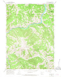
~ Pine Creek WY topo map, 1:24000 scale, 7.5 X 7.5 Minute, Historical, 1965, updated 1968
Pine Creek, Wyoming, USGS topographic map dated 1965.
Includes geographic coordinates (latitude and longitude). This topographic map is suitable for hiking, camping, and exploring, or framing it as a wall map.
Printed on-demand using high resolution imagery, on heavy weight and acid free paper, or alternatively on a variety of synthetic materials.
Topos available on paper, Waterproof, Poly, or Tyvek. Usually shipping rolled, unless combined with other folded maps in one order.
- Product Number: USGS-5614716
- Free digital map download (high-resolution, GeoPDF): Pine Creek, Wyoming (file size: 15 MB)
- Map Size: please refer to the dimensions of the GeoPDF map above
- Weight (paper map): ca. 55 grams
- Map Type: POD USGS Topographic Map
- Map Series: HTMC
- Map Verison: Historical
- Cell ID: 35237
- Scan ID: 340876
- Imprint Year: 1968
- Woodland Tint: Yes
- Aerial Photo Year: 1964
- Field Check Year: 1965
- Datum: NAD27
- Map Projection: Polyconic
- Map published by United States Geological Survey
- Map Language: English
- Scanner Resolution: 600 dpi
- Map Cell Name: Pine Creek
- Grid size: 7.5 X 7.5 Minute
- Date on map: 1965
- Map Scale: 1:24000
- Geographical region: Wyoming, United States
Neighboring Maps:
All neighboring USGS topo maps are available for sale online at a variety of scales.
Spatial coverage:
Topo map Pine Creek, Wyoming, covers the geographical area associated the following places:
- McCain Creek - Skull Creek - Cabin Creek - Little Greys River - Station Creek - West Table Creek Boat Ramp - West Table Creek - Elk Mountain - Pine Bar - East Table Creek - Keyser Creek - Whiskey Creek - Bailey Creek - Dry Wash - Aspen Hollow - Trail Creek - West Bailey Creek - East Table Creek Campground - Squirrel Creek - Davis Claim - East Elbow Campground - Pole Canyon - Cow Camp Creek - Station Creek Campground - Elbow Campground (historical) - Roos Creek - Iron Rim Creek - Martin Creek - Lake Gulch - Fire Box Creek - Bull Hollow - Pine Bar Diggings - Pine Creek
- Map Area ID: AREA43.2543.125-110.875-110.75
- Northwest corner Lat/Long code: USGSNW43.25-110.875
- Northeast corner Lat/Long code: USGSNE43.25-110.75
- Southwest corner Lat/Long code: USGSSW43.125-110.875
- Southeast corner Lat/Long code: USGSSE43.125-110.75
- Northern map edge Latitude: 43.25
- Southern map edge Latitude: 43.125
- Western map edge Longitude: -110.875
- Eastern map edge Longitude: -110.75


