
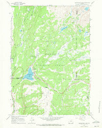
~ Meadowlark Lake WY topo map, 1:24000 scale, 7.5 X 7.5 Minute, Historical, 1967, updated 1971
Meadowlark Lake, Wyoming, USGS topographic map dated 1967.
Includes geographic coordinates (latitude and longitude). This topographic map is suitable for hiking, camping, and exploring, or framing it as a wall map.
Printed on-demand using high resolution imagery, on heavy weight and acid free paper, or alternatively on a variety of synthetic materials.
Topos available on paper, Waterproof, Poly, or Tyvek. Usually shipping rolled, unless combined with other folded maps in one order.
- Product Number: USGS-5613760
- Free digital map download (high-resolution, GeoPDF): Meadowlark Lake, Wyoming (file size: 10 MB)
- Map Size: please refer to the dimensions of the GeoPDF map above
- Weight (paper map): ca. 55 grams
- Map Type: POD USGS Topographic Map
- Map Series: HTMC
- Map Verison: Historical
- Cell ID: 28592
- Scan ID: 340407
- Imprint Year: 1971
- Woodland Tint: Yes
- Aerial Photo Year: 1966
- Field Check Year: 1967
- Datum: NAD27
- Map Projection: Polyconic
- Map published by United States Geological Survey
- Map Language: English
- Scanner Resolution: 600 dpi
- Map Cell Name: Meadowlark Lake
- Grid size: 7.5 X 7.5 Minute
- Date on map: 1967
- Map Scale: 1:24000
- Geographical region: Wyoming, United States
Neighboring Maps:
All neighboring USGS topo maps are available for sale online at a variety of scales.
Spatial coverage:
Topo map Meadowlark Lake, Wyoming, covers the geographical area associated the following places:
- Sitting Bull Campground - Deer Park Campground - Willow Creek - Virginia Creek - Lake View Campground - Lake McLain - Lake Creek Campground - Baby Wagon Creek - Maybelle Lake - East Tensleep Lake - Deer Haven Lodge - Bear Lake - Sitting Bull Park - Lake Creek - Meadowlark Ski Area - Island Park Campground - Bear Park - Warner Draw - Garnet Creek - Island Park - Lake Point Campground - Saint Christopher in the Bighorn - Bull Creek Campground - Stovepipe Creek - Deer Park - Varneys Memorial Camp - High Park - Meadowlark Lake - Middle Tensleep Creek - Indian Creek - Willow Park Picnic Area - Meadow Lark Lake Census Designated Place - Bull Creek - Meadowlark Lodge - Tensleep Reservoir - High Park Lookout - Tensleep Reservoir Dam
- Map Area ID: AREA44.2544.125-107.25-107.125
- Northwest corner Lat/Long code: USGSNW44.25-107.25
- Northeast corner Lat/Long code: USGSNE44.25-107.125
- Southwest corner Lat/Long code: USGSSW44.125-107.25
- Southeast corner Lat/Long code: USGSSE44.125-107.125
- Northern map edge Latitude: 44.25
- Southern map edge Latitude: 44.125
- Western map edge Longitude: -107.25
- Eastern map edge Longitude: -107.125


