
~ Lava Mountain WY topo map, 1:24000 scale, 7.5 X 7.5 Minute, Historical, 1965, updated 1985
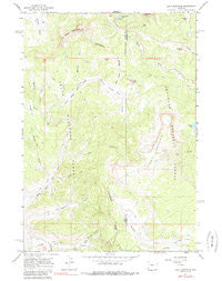
Lava Mountain, Wyoming, USGS topographic map dated 1965.
Includes geographic coordinates (latitude and longitude). This topographic map is suitable for hiking, camping, and exploring, or framing it as a wall map.
Printed on-demand using high resolution imagery, on heavy weight and acid free paper, or alternatively on a variety of synthetic materials.
Topos available on paper, Waterproof, Poly, or Tyvek. Usually shipping rolled, unless combined with other folded maps in one order.
- Product Number: USGS-5613308
- Free digital map download (high-resolution, GeoPDF): Lava Mountain, Wyoming (file size: 12 MB)
- Map Size: please refer to the dimensions of the GeoPDF map above
- Weight (paper map): ca. 55 grams
- Map Type: POD USGS Topographic Map
- Map Series: HTMC
- Map Verison: Historical
- Cell ID: 25120
- Scan ID: 340190
- Imprint Year: 1985
- Woodland Tint: Yes
- Photo Inspection Year: 1979
- Aerial Photo Year: 1964
- Field Check Year: 1965
- Datum: NAD27
- Map Projection: Polyconic
- Map published by United States Geological Survey
- Map Language: English
- Scanner Resolution: 600 dpi
- Map Cell Name: Lava Mountain
- Grid size: 7.5 X 7.5 Minute
- Date on map: 1965
- Map Scale: 1:24000
- Geographical region: Wyoming, United States
Neighboring Maps:
All neighboring USGS topo maps are available for sale online at a variety of scales.
Spatial coverage:
Topo map Lava Mountain, Wyoming, covers the geographical area associated the following places:
- Pink Creek - Pill Creek - Barbers Point - North Fish Creek Trail - Spruce Creek Trail - Hardscrabble Creek - Pelham Lake - Burnt Fork - Calf Creek - Squaw Basin - Mountain Creek - Wind River Lake - Larkspur Creek - Moccasin Creek - Hereford Creek - Pilot Knob - Open Fork - Two Ocean Mountain - Lava Mountain Number One Mine - Brooks Lake Lodge - Lava Mountain - Moccasin Basin - Square Lake - Game Warden Creek - First Gulch - Sublette Peak - Togwotee Pass - Beauty Park Creek - Beauty Park - Wind River Lake Picnic Area - Dry Gulch - Second Gulch
- Map Area ID: AREA43.7543.625-110.125-110
- Northwest corner Lat/Long code: USGSNW43.75-110.125
- Northeast corner Lat/Long code: USGSNE43.75-110
- Southwest corner Lat/Long code: USGSSW43.625-110.125
- Southeast corner Lat/Long code: USGSSE43.625-110
- Northern map edge Latitude: 43.75
- Southern map edge Latitude: 43.625
- Western map edge Longitude: -110.125
- Eastern map edge Longitude: -110


