
~ La Prele Reservoir WY topo map, 1:24000 scale, 7.5 X 7.5 Minute, Historical, 1964, updated 1968
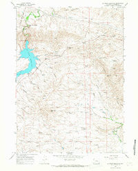
La Prele Reservoir, Wyoming, USGS topographic map dated 1964.
Includes geographic coordinates (latitude and longitude). This topographic map is suitable for hiking, camping, and exploring, or framing it as a wall map.
Printed on-demand using high resolution imagery, on heavy weight and acid free paper, or alternatively on a variety of synthetic materials.
Topos available on paper, Waterproof, Poly, or Tyvek. Usually shipping rolled, unless combined with other folded maps in one order.
- Product Number: USGS-5613162
- Free digital map download (high-resolution, GeoPDF): La Prele Reservoir, Wyoming (file size: 12 MB)
- Map Size: please refer to the dimensions of the GeoPDF map above
- Weight (paper map): ca. 55 grams
- Map Type: POD USGS Topographic Map
- Map Series: HTMC
- Map Verison: Historical
- Cell ID: 24156
- Scan ID: 340119
- Imprint Year: 1968
- Woodland Tint: Yes
- Aerial Photo Year: 1963
- Field Check Year: 1964
- Datum: NAD27
- Map Projection: Polyconic
- Map published by United States Geological Survey
- Map Language: English
- Scanner Resolution: 600 dpi
- Map Cell Name: La Prele Reservoir
- Grid size: 7.5 X 7.5 Minute
- Date on map: 1964
- Map Scale: 1:24000
- Geographical region: Wyoming, United States
Neighboring Maps:
All neighboring USGS topo maps are available for sale online at a variety of scales.
Spatial coverage:
Topo map La Prele Reservoir, Wyoming, covers the geographical area associated the following places:
- Middle Fork King Creek - Tomahawk Peak - Ayres Natural Bridge - Stinson Hill - Wilson Draw - South Fork King Creek - Johnson Mailbox Hill - Johnson Draw - Curtis Creek - Harris Creek - Wilson Number 1 Dam - Whitaker Draw - KATH-FM (Douglas) - Dull Knife Creek - Hazenville Pass - King Creek - Buckshot Creek - Wilson Number 1 Reservoir - Sheep Creek - Loco Draw - Krazier Creek - Nine Mile Hill - Rattlesnake Hill - Willow Spring - La Prele Reservoir - Center Realty Reservoir Number 1 - Sand Creek - Bulls Run - Schofield Pass - Tomahawk Draw - Center Realty Reservoir Number 1 Dam - La Prele Dam - North Fork King Creek
- Map Area ID: AREA42.7542.625-105.625-105.5
- Northwest corner Lat/Long code: USGSNW42.75-105.625
- Northeast corner Lat/Long code: USGSNE42.75-105.5
- Southwest corner Lat/Long code: USGSSW42.625-105.625
- Southeast corner Lat/Long code: USGSSE42.625-105.5
- Northern map edge Latitude: 42.75
- Southern map edge Latitude: 42.625
- Western map edge Longitude: -105.625
- Eastern map edge Longitude: -105.5


