
~ Jenny Lake WY topo map, 1:24000 scale, 7.5 X 7.5 Minute, Historical, 1968, updated 1975
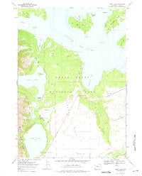
Jenny Lake, Wyoming, USGS topographic map dated 1968.
Includes geographic coordinates (latitude and longitude). This topographic map is suitable for hiking, camping, and exploring, or framing it as a wall map.
Printed on-demand using high resolution imagery, on heavy weight and acid free paper, or alternatively on a variety of synthetic materials.
Topos available on paper, Waterproof, Poly, or Tyvek. Usually shipping rolled, unless combined with other folded maps in one order.
- Product Number: USGS-5612950
- Free digital map download (high-resolution, GeoPDF): Jenny Lake, Wyoming (file size: 9 MB)
- Map Size: please refer to the dimensions of the GeoPDF map above
- Weight (paper map): ca. 55 grams
- Map Type: POD USGS Topographic Map
- Map Series: HTMC
- Map Verison: Historical
- Cell ID: 22537
- Scan ID: 340010
- Imprint Year: 1975
- Woodland Tint: Yes
- Aerial Photo Year: 1967
- Field Check Year: 1968
- Datum: NAD27
- Map Projection: Polyconic
- Map published by United States Geological Survey
- Map Language: English
- Scanner Resolution: 600 dpi
- Map Cell Name: Jenny Lake
- Grid size: 7.5 X 7.5 Minute
- Date on map: 1968
- Map Scale: 1:24000
- Geographical region: Wyoming, United States
Neighboring Maps:
All neighboring USGS topo maps are available for sale online at a variety of scales.
Spatial coverage:
Topo map Jenny Lake, Wyoming, covers the geographical area associated the following places:
- Moran Bay - North Moran Creek - Paintbrush Canyon Trail - Bearpaw Bay - Snowshoe Canyon - South Bar - Jenny Lake Trail - Mystic Isle - Marie Island - Deadman Point - Boulder Island - Inspiration Point - Jenny Lake Campground - Hermitage Point - Ribbon Cascade - North Jenny Lake Junction - Jenny Lake - Badger Island - Cascade Creek - Jenny Lake Lodge - String Lake - North Bar Bay - Leigh Lake - Jenny Lake Moraine Horse Trail - Cathedral Group Scenic Turnout - Laurel Lake - Grand Teton National Park - Mount Moran Scenic Turnout - Spalding Bay - Cascade Canyon - Trapper Lake - Hanging Canyon - String Lake Trail - Dollar Island - Hidden Falls Horse Trail - Elk Island - Grassy Island - Jenny Lake Post Office (historical) - Bearpaw Lake - Burned Ridge - Donoho Point - Burnt Ridge
- Map Area ID: AREA43.87543.75-110.75-110.625
- Northwest corner Lat/Long code: USGSNW43.875-110.75
- Northeast corner Lat/Long code: USGSNE43.875-110.625
- Southwest corner Lat/Long code: USGSSW43.75-110.75
- Southeast corner Lat/Long code: USGSSE43.75-110.625
- Northern map edge Latitude: 43.875
- Southern map edge Latitude: 43.75
- Western map edge Longitude: -110.75
- Eastern map edge Longitude: -110.625


