
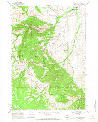
~ Dayton South WY topo map, 1:24000 scale, 7.5 X 7.5 Minute, Historical, 1964, updated 1968
Dayton South, Wyoming, USGS topographic map dated 1964.
Includes geographic coordinates (latitude and longitude). This topographic map is suitable for hiking, camping, and exploring, or framing it as a wall map.
Printed on-demand using high resolution imagery, on heavy weight and acid free paper, or alternatively on a variety of synthetic materials.
Topos available on paper, Waterproof, Poly, or Tyvek. Usually shipping rolled, unless combined with other folded maps in one order.
- Product Number: USGS-5611146
- Free digital map download (high-resolution, GeoPDF): Dayton South, Wyoming (file size: 14 MB)
- Map Size: please refer to the dimensions of the GeoPDF map above
- Weight (paper map): ca. 55 grams
- Map Type: POD USGS Topographic Map
- Map Series: HTMC
- Map Verison: Historical
- Cell ID: 11504
- Scan ID: 339119
- Imprint Year: 1968
- Woodland Tint: Yes
- Aerial Photo Year: 1963
- Field Check Year: 1964
- Datum: NAD27
- Map Projection: Polyconic
- Map published by United States Geological Survey
- Map Language: English
- Scanner Resolution: 600 dpi
- Map Cell Name: Dayton South
- Grid size: 7.5 X 7.5 Minute
- Date on map: 1964
- Map Scale: 1:24000
- Geographical region: Wyoming, United States
Neighboring Maps:
All neighboring USGS topo maps are available for sale online at a variety of scales.
Spatial coverage:
Topo map Dayton South, Wyoming, covers the geographical area associated the following places:
- Crystal Spring Draw - Town of Dayton - Dayton Cemetery - Steam Shovel Draw - Xingu Airstrip - Turkey Creek - Bulls Eye Point - Big Horn Mountain Mine - South Fork Little Tongue River - Horseshoe Ranch - Model Geyser - Deer Park - Steamboat Point - Fallen City - South Side Ditch - Frisbie Ditch - Sand Turn - Herdrick Ridge - Tongue Canyon - Pasture Creek - Tongue Butte - Sheep Creek - Tongue River High School - Tongue Canyon Campground - Amsden Creek - Mock Gulch - Tongue River Campground - Hairpin Turn - Dayton Volunteer Fire and Rescue Department - Elephant Foot - East Fork Little Tongue River - Trail Creek - Sheridan County Big Game Winter Range - Whitetail Creek - Horseshoe Mountain - I X L Ranch - Needles Eye
- Map Area ID: AREA44.87544.75-107.375-107.25
- Northwest corner Lat/Long code: USGSNW44.875-107.375
- Northeast corner Lat/Long code: USGSNE44.875-107.25
- Southwest corner Lat/Long code: USGSSW44.75-107.375
- Southeast corner Lat/Long code: USGSSE44.75-107.25
- Northern map edge Latitude: 44.875
- Southern map edge Latitude: 44.75
- Western map edge Longitude: -107.375
- Eastern map edge Longitude: -107.25


